![]()
![]()
![]()
![]()
![]()
![]()
![]()
![]()
![]()
![]()
![]()
![]()
|
|
|
Walking the Camino Arles 2010 – A Journal
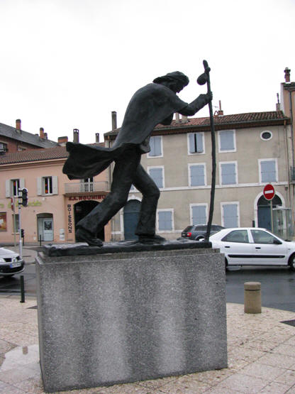
Statue of a Pilgrim in Downtown Castres
Prologue: In early 2010 my friend Mike Barker was on another creativity binge and as usual he had attached a good dollop of exercise to his proposed initiative – “What say you join me and we’ll find another couple guys and walk a section of Camino in France, perhaps two weeks in the fall. I’m thinking we should look at a section west of Montpellier on the Arles route (the route joining Santiago and Rome) because of the presence of mountains and likely associated good geology which you’ll like!” Yea, sure!
That Mike was suggesting a(nother) walk on the Camino was not surprising. He has first walked the main Spanish trail (Camino Frances) from Roncesvalles to Santiago in Spain in 2002. He had then co-opted me to walk it with him a second time in 2004, this time leaving from St. Jean Pied la Port just across the Spanish border in France. In 2005 with his wife Fran and daughter Christine he again covered the section from Leon in Spain to Santiago, and with his wife in 2006 he initiated his walk in again in France but on the more southern route which eventually makes its way via Jaca to join the standard Camino Frances at Puente la Reina. In 2008 he and his wife decided they would walk from near the Swiss border south through Italy to Rome but the trip did not meet their expectations because of the scarcity of other pilgrims on the road and they terminated early. In 2009 he again walked the last two weeks of the Camino Frances from Leon to Santiago with his grandson. (Subsequent to the 2010 adventure being described here Mike and Fran walked the more challenging northern route across Spain, a route which hugs the Atlantic for most of its trend.)
So without any commitment I agreed to consider his proposition for a few days and get back. On examination I had enough Aeroplan points to cover the flight to Paris and return. The mountains did intrigue me, although I knew that understanding the geology of the countryside would be incidental. However, a 14 day trip would leave us to terminate somewhere east of Toulouse in the middle of nowhere; might as well simply do the Montpellier-Toulouse section and be done with it! Mike agreed to the extension (“we’ll plan for 21 days”) and I “signed-on”.
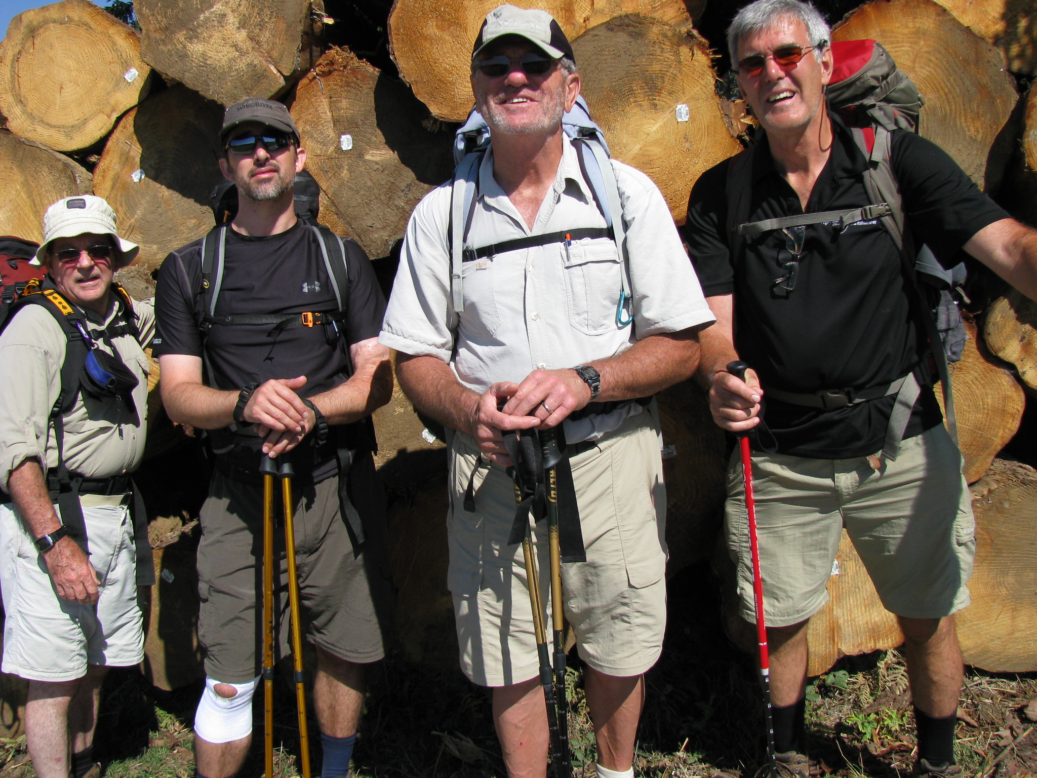
Who else could we press into this adventure? Mike suggested his son-in-law Paul, an air engineer on heavy water bombers with the Ontario’s Ministry of Natural Resources forest firefighting system. Paul had recently expressed some interest in accompanying Mike on one of his jaunts. I suggested the fourth candidate might well be Brian Campbell, a business acquaintance from the senior management team of Thunder Bay’s Confederation College who in my mind was cut from the same bolt of cloth as Mike. They would get along well! We arranged a little dinner in Thunder Bay to get the two guys acquainted and Brian also “signed on”! By the way, did I mention that Brian was conversant in French (oh so important!)! We had our team!
We had elected to go in the fall as the weather in southern France and Spain tends to be better and the temperatures less severe. Additionally, Paul’s manager was unlikely to give him holidays in key portion of the fire season. Indeed, all of us were aware that if the fire hazard got high in early September Paul’s holidays were readily susceptible to cancellation.
I began my training for the mid-September walk on the May 24 weekend of my 68th year. The intent would be to walk at least 5 days a week beginning with small walks, say 5 km, and working up to walks of 25 km in late August-early September. There is some rationale for also practicing walking with a 20-pound pack; however, I had not done so in 2004 to no apparent detriment and decided I would follow a similar regimen this time out. My walks initially focused on streets in the Rosslyn area southwest of Thunder Bay and, as my body became accustomed to the increasing exercise, they spread outward up the Harstone Road to Stanley and eventually across the Stanley bridge and back on River Road, a distance of about 26 km. About mid-summer I made the decision to invest in a new pair of hiking boots and settled on a set of up-scale Keens. My major concern was that I would not have sufficient distance on them by mid-September to have them appropriately broken in. In practice I did have a couple minor blister problems on day three or so, and some difficulty early getting the right tension at the ankles, but after some appropriate attention thereto for a few days the boots proved to be excellent companions.
Mike, at that time 71, had a daily routine of walking for an hour or better most days and only had to put on the occasional extra distance to get himself geared up for the trial ahead. We subsequently discovered that Brian had not put in the training time and distance usually recommended for our mission but the lack of practice appeared not to have held him back as he would inevitably be the first member of the party to ‘attain the summit’ of the day, whatever it may be. He certainly gave the appearance of having great affinity for the fine art of walking and the fact that he was in his early 60s made narry a difference. Paul, pushing 40, had likewise not put in the recommended training time and distance, at least in part as a result of job demands; however, unlike Brian, Paul was subjected to all the expected aches and pains of that deficiency.
Tuesday/Wednesday, Sep 14/15: Day 1 – Over the Pond and to Montpellier I met Brian at the Thunder Bay airport mid-afternoon just before scheduled plane time. In Toronto we looked for Mike and Paul in the domestic arrivals area to no avail so we made our way over the long walk to the international departures area and there were our walking partners ‘working out’ in the bar; Mike agreed to provide us a penance-beer for not waiting for us. (The trip was off a good foot!). I changed some currency (1E = $1.49C) and after some waiting we finally boarded our 777. The plane had up to 9 seats across and held a total of 418 passengers; all seats appeared to be full. I coincidentally fell into an aisle seat behind Mike.
Mike had given Heather, his daughter and Paul’s wife, the wrong departure date and she only casually realized it the night before Paul was to leave. Fortunately, she was able to get his reservations all changed to the correct flights the night before and at about half of the regular cost of doing so!
The plane had a bit of a mechanical problem and we were on the tarmac for some several minutes after leaving the ramp and prior to takeoff. We eventually staggered into the air and turned east toward Paris. Dinner, wine, TV (Big Bang/2½ Men), one Hopalong Cassidy movie, some dozing, and breakfast found us ready to land at Charles De Gaul airport on time at about 9.30am local. Customs was smooth but as we made our way to the train station by foot (our train left from the airport – how civilized is that!) we ran into a bunch of “kids” in military uniforms touting automatic weapons who had halted foot traffic due to an abandoned piece of baggage. That little digression cost us 45 minutes. When we finally arrived at the train station we could not retrieve our pre-purchased tickets from the platform machine. After about 25 minutes of looking at and standing in line a “ticket guy” showed us the secret of ticket retrieval, and we were good to go with an hour to spare.
The train trip to Montpellier was uneventful. Much of the country we rolled through was devoted to farming with grain and ‘white cows’ (Charlois?) being the prominent agriculture products, particularly in the north. The trip produced only 2 horses and one flock of sheep. The west side of the Alps in the area of Grenoble was visible in the distance to the east.
We arrived in Montpellier on schedule at 5.10pm. Our hotel was supposedly a 10 minute walk from the train station but getting there directly was not possible as we had to detour around several sets of tracks and back through the station. Our hotel was the Royal Hotel (a Best Western), older, with some old world charm, but quite well appointed, even had air conditioning! It was situated on a rather upscale downtown street with plenty of shops and a modern local LRT system in place. The street it was on boasted a line of mature palms (royal?) on one side – most impressive
After getting our rooms and our baggage stowed we went back outside looking for a place to eat. We eventually wound up in the central town square a few hundred meters and slightly up-grade form the hotel. The square was large and bounded by a mixture of the new and the old in architecture, but all in good repair. The square likewise housed numerous restaurants under canvass as well as a multitude of shops sited in the buildings lining the square. The square was a happening place with a large number of people in attendance. In addition to diners like us there were shoppers, there was a labor protest underway objecting to the proposal to move the retirement age in France from 60 to 62 (!), there was a young female songstress busking in another area with a small amplifier used to get the music out. We later went into an adjoining grocery to get tomorrow’s lunch and some snacks. It appeared to be filled with students – we later came to realize that the heavy youth population in Montpellier comes from the city’s strong post-secondary education system.
Back in the hotel we watched a little TV, and fell asleep. It was later reported I apparently snored a bit!
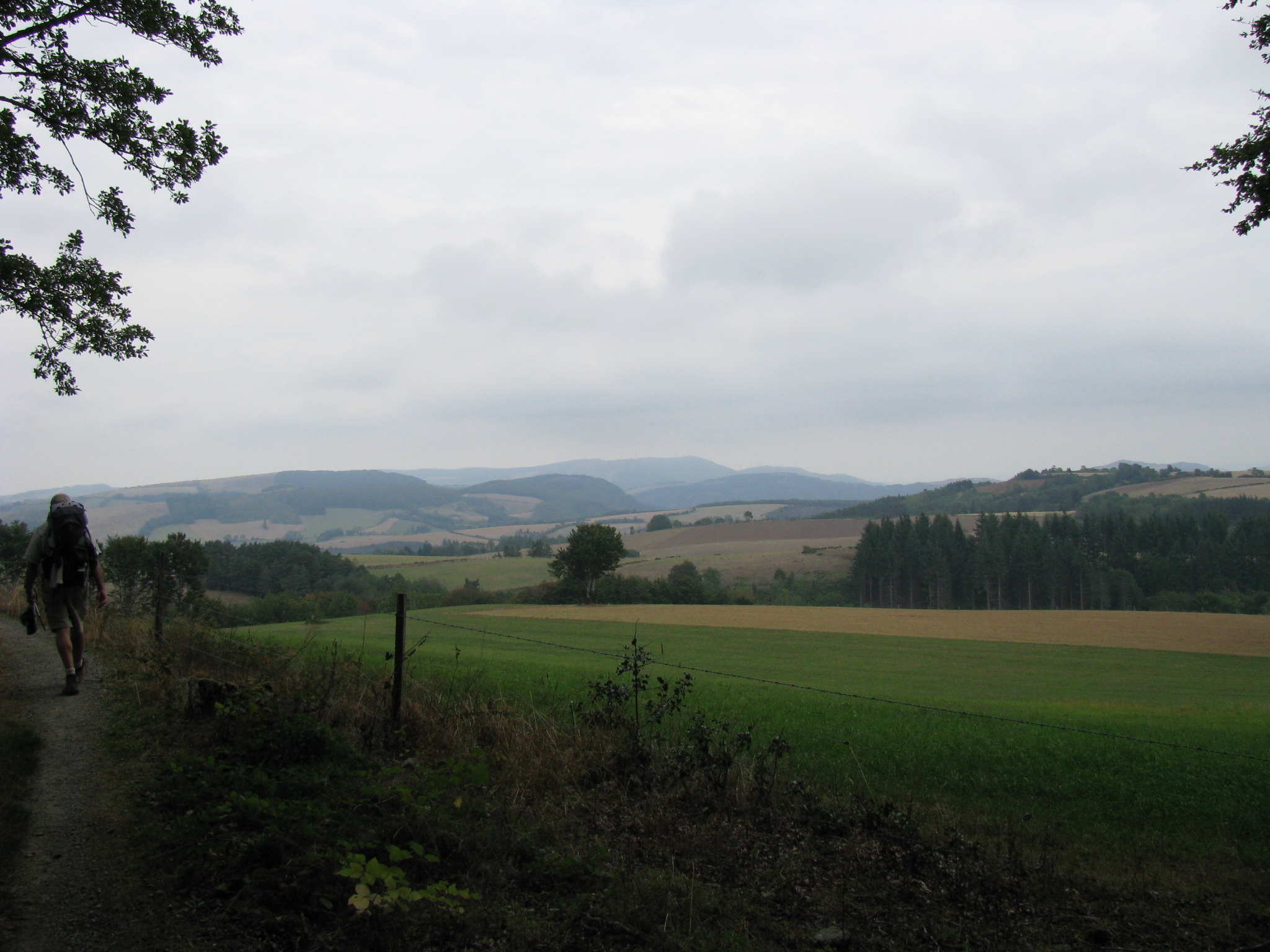
Thursday, Sep 16: Day 2 – Montpellier to Saint-Guilhem-le-Desert – 28 km/22km walked In the morning we had breakfast in the hotel breakfast room – usual cold fare and quite well done – and caught a prearranged cab outside the hotel just before 8am destined to take us through Montpellier to a little village called Grabels where we had planned to begin the walk. The 30 year old cabbie, Frank Mantangerand, had some English, was quite garrulous, and used a history book he drew out of a package in the front seat as a tool for impressing his ridership.
The cabbie dropped us off at the center of Grabels adjacent to a small monument which we used for the background for the obligatory, walk-initiating photo. After checking our boots and packs we began walking at approximately 8.17am on the Camino trail known in France as GR 653. Within a kilometer we promptly got lost but were pleased that we recognized the fact that we were not where we should have been. A 20 minute backtrack to the public school (looked like the first day of class) and a request of a young mother who was out walking as to where the trail went got us properly oriented. Up and over the steep hill she indicated so off we went, realizing immediately that Brian (described in my notes as “like a gazelle”) was either in good shape or we were going to have to carry him later in the day!
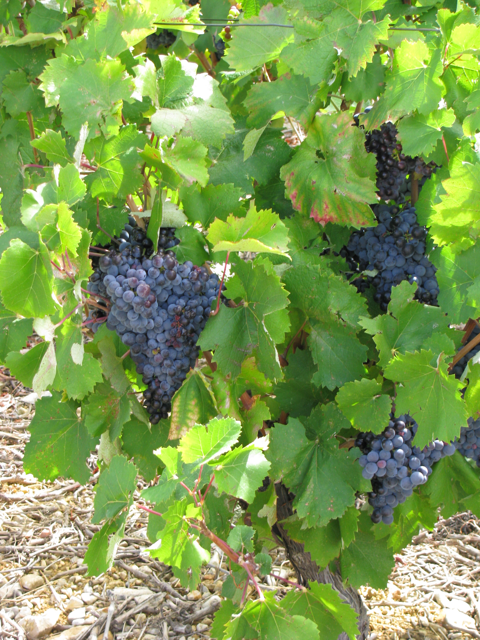
As the morning progressed we encountered numerous situations where large snails were in the process of feeding on wild dill plants along the roadside, passed olive orchards in fruit, and passed many vineyards awaiting harvest. Along one back lane we saw a fruit-laden pomegranate tree in an adjoining back yard (the only one of the trip).
Later in the morning we met four Frenchmen, one couple and two guys, heading in our direction; they had been on the trail since Arles. We subsequently followed them along the immediate abandoned rail line section of the trail and played ‘rabbit and hound’ with them over the next few days, exchanging places several times. Later in the morning we passed another French couple, late 60’s/early 70s, who were plodding westerly with great determination. We interacted with them several times over the next few days (Odette and Francis from Normandy) and came to understand that they had already at an earlier point in time done the 1500km to Santiago and return. We had our first on-the-trail lunch at the cemetery in the village of Aniane, washing it down with Cokes purchased from a local shop.
In the early afternoon we crossed a shallow valley filled with vineyards stretching up the valley walls to the tree line. The trail took us on farming roads among the vineyards and the odd olive orchard. Additionally, the valley held several great examples of large, apparently feral (?) yucca plants as well as several prickly pear cacti effusing purple fruit. There was much evidence of rooting activity of wild boar within the valley. We passed the older couple again when they were having lunch at an intersection of two farm roads and continued past them up the valley side, watching and listening as automated grape harvesters were being worked on some of the vineyards below. Map-man Mike suddenly realized we were lost again! We must have missed a trail marker but no problem; we’ll just scout around until we find it. One hour (and a heavy shower) later we finally found the missed marker at the location where the older couple had been having lunch. Onward and forward!
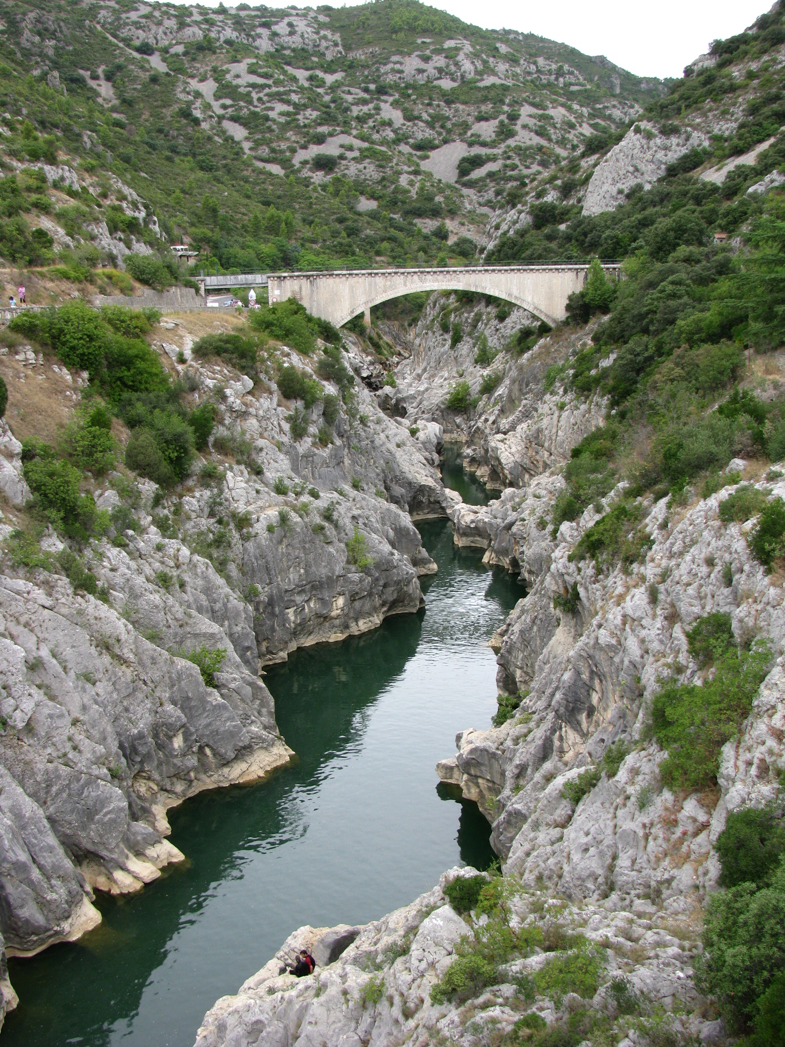
The trail took us out of the valley and eventually to Pont du Diable at the mouth of a gorge which carries the river Herault from the high country to the north out on to the valley to the south. The gorge itself is at this point relatively deep, and displays the effective power of running water on massive limestone over perhaps the last million years. Two bridges span the river Herault at this point, perhaps 70m above the low summer water levels. The first, Pont du Diable, is obviously quite old but recently reconstructed for its historical and recreational values; it is closed to vehicular traffic but bears the embedded scallop shell symbol of the Camino. The second is a modern four lane bridge designed to take vehicular traffic over the Herault in support of the economic well-being of this part of Southern France.
Traffic Bridge Spanning the Gorge of the River Heralut
After crossing the river we turned right and followed the road along the river Herault some 3 to 4 km upstream to Saint-Guilhem-le-Desert, partaking in some significant scenery of steep limestone cliffs separated by likewise steep, wooded mountainsides, all reaching down to the quiet river below. The deeply incised nature of the river bed suggested a much larger and more turbulent river when the snow melts in the spring. The center of Saint-Guilhem is perhaps a kilometer west off the highway and is accessed by a pleasant walk along a small brook which traverses through the village and houses some numbers of trout, likely related to the hatchery at the junction with the river Herault. However, there are a couple restaurant/bars and shops at the junction with the highway and it was there that Brian and I found ourselves arriving first and of necessity waiting for our travelling companions before making the jaunt westerly up along the brook into the village. Since we were both aware of the old adage that says that “idle hands are the Devil’s workshop” and since we did not want to become “tools” of the Devil, and since there was a bar handy, we made the decision to buy a beer while we waited so as to keep our hands occupied. I believe we were successful in foiling the Devil because a beer-and-a-half later when the boys did arrive the he was nowhere in sight.
We walked the kilometer into Saint-Guilhem and immediately made our way to Maison Sainte-Elle, a gite (translation: albergue or hostel) operated by the Nuns of the Order of Carmel Saint Joseph, a seasonal accommodation for pilgrims on the trail. We were the last to be accommodated that evening and shared a room with one French pilgrim – Leddie, from Toulouse, perhaps late 40’s, with thick glasses, and perhaps a little eccentric – who had been part of the French foursome encountered earlier in the day. It turned out that we would share the trail, meals, and accommodation with Leddie several times over the next two weeks. That night Leddie, for the first couple hours after he went to sleep, demonstrated the less than common behavior of noisily scratching his head as well as carrying on a broken conversation. We were later to discover we were not the only ones to have noted this behavior.
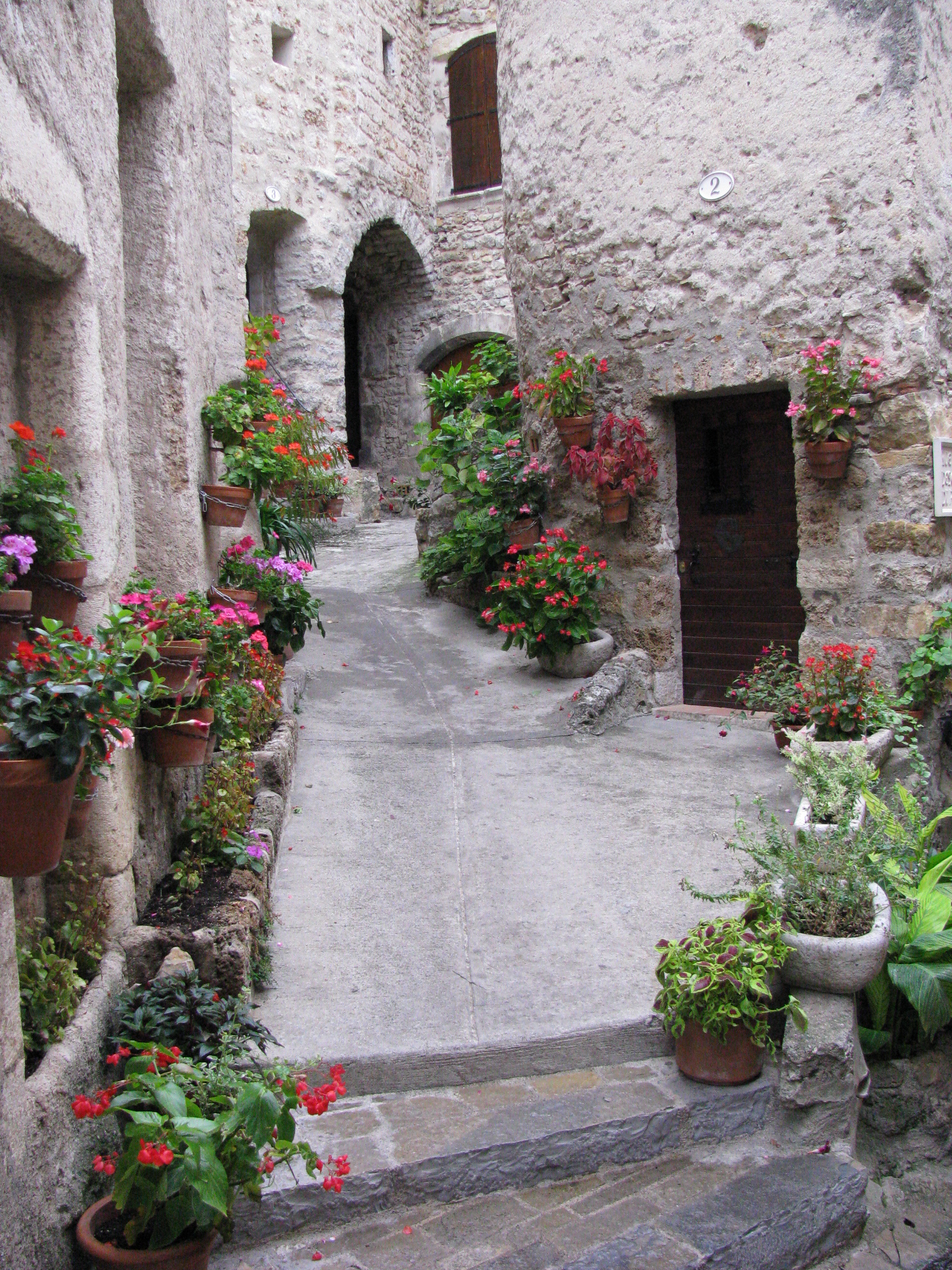
An Attractive Street in Saint-Guilhem-le-Desert St. Guilhem-le-Desert is really a neat little village. It is spectacularly sited at the head of a limestone valley in a steep-sided cirque (a usually three-sided ‘bowl-shaped’ depression created over thousands of years through erosion via the head of an active glacier). The village was founded in 804 by Guilhem, a cousin to Charlemagne and a companion in war. The core of the village is centered on a small square guarded a large spreading deciduous tree estimated to be several centuries old. The key feature of interest off the square is an historical abbey church that was consecrated in 1076, deconsecrated after the French Revolution, and then repopulated again by the Nuns of the Order of Carmel in 1976. A claimed “Fragment of the True Cross” donated by Charlemagne is housed in the church. Most of the village buildings as well as the streets and bridges are constructed of stone. Because of its inherent attractiveness as well as its history the community has become something of a stop for local tourist buses and as a result houses some upscale arts and crafts shops; however, most were closed as it was off-season. There is the ruined Chateau de Verdas perched on the hill high above the village; however, access by trial up the mountain is now closed due to the inherent danger of both the access and the site.
We ate at a local restaurant and feasted on what turned out to be a widespread dish in rural southern France – cassolet, generally a baked dish featuring duck (Canard) and green beans. Its frequency on menus across this part of southern France finally answered for me the burning question from 2004 as to what happens to the rest of the duck grown specifically in France for foie gras.
In summing up our first day the 22 kilometer walk took us 7 hours, but we should expect to get better with time as the bodies harden up. Mike, Brian and I generally could have been described as OK, but Paul was a bit sore and would likely get more so tomorrow. The locals we met during the day generally knew who we were and what we were doing, were most helpful, and generally smiled in friendship. Of interest, we did run into one blond 30-something, Washington-based, Canadian female in the gite who was in the area with a number of friends for a concert. She and her friends tended to raise the noise level of the digs for a couple hours later in the evening but the “old men” of our party were blissfully carried far away by exhaustion-borne sleep.
Friday, Sep 17: Day 3 – Saint-Guilhem-le-Desert to Saint-Jean-de-la-Blaquiere – 24 km On Friday am we had an early breakfast of items (e.g., yogurt) purchased locally the previous evening, sharing a table with the French foursome. Our new acquaintance Leddie left with that party just ahead of us. The trail initially led up along the brook toward the head of the cirque passing a rustic homestead or two on the way. At least one of those facilities had hounds, penned but in good voice, which was a bit of a surprise. We came to understand the presence of the hounds the following Sunday. After perhaps 25 minutes along the brook the trail led us to the southern side of the cirque and up we started on a switch-backed gravel pathway through a reasonably well-treed conifer forest. The climb took us about an hour and provided some great vistas, particularly of some abandoned heavily terraced ‘fields’ (vineyards?) on the far side of the cirque, and the ruins of the Chateau de Verdus perched above Saint Guilhem. The village itself was obscured by topography.
We passed the older French couple going up the switchbacks but they finally caught us again after we attained the top and had started out across the plateau on “forest” roads, mainly in a gravel state. Those roads are part of the infrastructure of two locally designated and managed community forests. After skirting across the edge of the plateau the roads finally took us down off the heights heading in the direction of a small village - Montpeyroux - visible below. About three quarters of the way down off the plateau the trail passed a fingerboard sign entitled Enclos Neolithique pointing to a rough wall of dry-laid rocks along the side of the road. Exploration further into the bush revealed a circular stone walled feature, perhaps 6 feet across and 6 feet deep with an outward protruding extension perhaps two feet across and four feet long which might serve as an entryway. The walls of the feature were composed of dry-laid country rock and about 18 inches thick. One could visualize the structure, with or without a hide and/or a pole roof, as potential rudimentary protective infrastructure for a local shepherd, or even as an easily closed surround for a few sheep or goats. However, the accompanying sign was too casual for it to be formally dated to the Neolithic period and its age would be best described as uncertain. Just before we broke off the mountain the trail led past an old castle – Las Castelas – several hundred meters long and built on a relatively level section of hill side. It obviously had been abandoned for some time but a nearby sign indicated restoration was now the name of the game and most of the outer walls demonstrated some restoration effort. From what we could tell there did not appear to be any structures within the castle walls, although access was barred by a large locked wooden door.
We crossed the creek at the foot of the hill and edged up along the side of the village on a road which wound past an interesting cemetery. At the west end of the town we noted a tap in a small, well-used, rocked alcove along the road and stopped to refresh our water bottles. A lady on the second story of the nearby residence appeared at the window and pleasantly confirmed that the water was potable and provided more detailed direction as to egress from the village.
Harvest-ready Grapes Along the Trail
Within a half hour we were back within vineyard country and given the presence of some large grape bunches adjacent to the road I have to admit we took the advantage of snitching a few to grace our pallets! It may also be time to note that blackberries could be found in good quantity along much of the trail at lower elevations, particularly in its eastern sections. However, they were characteristically small and appeared to be suffering from lack of rain.
A short distance out of Montpeyroux we crossed the Pont Vieux on the river Rouvignou where engraving on one abutment indicated the distance from that bridge to Santiago along Saint Jacques de Compostelle was 1474 kilometers; engraving on a second abutment appeared to indicate that the bridge had been constructed in 1731 and reconstructed in 1771 and again in 2009. The trail beyond Pont Vieux took us back up to higher elevations where we enjoyed good scenery from some comfortable forest roads. Just before Saint-Jean-de-la-Blaquiere the trail pointed down over the hill off the plateau and we found the steepness of the slope and the loose rocks and gravel a sweaty challenge. It was along a small section of this downhill that we encountered a dry stone wall about four feet high constructed of essentially flat stones laid perpendicularly – the only one of its kind on the trip.
When we arrived at Saint-Jean-de-la-Blaquiere by the road along the river at about 4pm we were not sure where to go. However, we saw the French party sitting at an outdoor bar having a beer and decided to follow suit while reconnoitering the village and our next move. It turned out that the lady managing the bar and restaurant also looked after the local gite (probably municipally operated). We were fortunate to get the last beds. Our room contained two double bunks of the steel variety and three single beds. Leddie was already ensconced in the room in one of the upper bunks. Just as we were getting organized Odette and Francis arrived so we gave them their choice of beds. Because of the close proximity of the single beds the lady felt more comfortable on one of the doubles and so Brian and I and Mike took the three cozy singles, and Paul the lower of the other double decker. The room was probably of sufficient size to hold the three single beds!
The facility had one washroom with one toilet but no toilet seat (lest one linger reading “The Economist”!). There was lots of hot water so I washed clothes. I managed to find some space to hang them in the tiny courtyard, which inconveniently had to be entered via another bedroom; however, they did not dry well and had to ride outside on my pack the next day. We eventually concluded this to have been the basest accommodation we had during our French sojourn.
For dinner we ended back at the restaurant/bar we had visited upon arriving in town. At one point Mike suggested we get a cab and visit a supposedly highly reputable restaurant some five kilometers back down the road; however, when looking into it further we were advised that that restaurant had closed a few months back. Additionally, we were advised that the best restaurant in town was the one where we’d had the beer so our decision was not difficult.
That restaurant turned out to be quite well appointed and was full to the point we had to wait a few minutes for a table. Although I can recall the food was good (Rhetorical question: is the quality of food under these circumstances directly proportional to the quantity of wine consumed??) I cannot for the life of me remember what I ate. I can recall we carried on a neat conversation with a holidaying Dutch dentist who had created and was “plugging” a sort of “Dentists without Borders” initiative he’d established in one of the south-central African countries. He was in the restaurant because his friend deemed it to be one of the better ones in the area.
Saturday, Sep 18: Day 4 – Saint-Jean-de-la-Blaquiere to Lodeve – 15 km Saturday dawned clear and after a quick repast of the food at hand, and a brief pause to take a photo of the scallop shell over the door of the Gite Sainte Jacques, the three of us struck out across the town and northwest in the general direction of Lodeve. At the edge of town the gravelly trail took us up onto the plateau again. With about three quarters of the climb behind us we heard an engine sound and in about 5 minutes we were overtaken by two young lads on motorbikes – including helmets and the brightly colored uniforms of the sport – who were obviously off an their Saturday morning adventure of cross-country cycling. We never saw them again.
On achieving the top of the ridge we were pleasantly surprised again to be on forest roads in a regenerated conifer (mainly pine) forest. The trees appeared to have been planted in small patches and ranged from perhaps 25 to 80 years old, with some of the older stands certainly sawlog-ready again. Wild blooming heather was noted frequently along the road edges. We passed one location where the local forest managers had placed a large steel water tank of perhaps 50,000 liters to provide a source of water for forest fire management purposes.
Our mid-morning coffee was acquired from a coffee shop in a former abbey of some antiquity; it appeared the coffee shop, gift shop, and other tourist offerings were a means of securing funding to maintain the buildings and grounds. The gift shop had photos of the local remains of what might be best described as a prehistoric sweat lodge. The coffee shop also carried casts of footprints in limestone of a Triassic lizard. The grounds of the abbey were quite impressive with large planted trees and manicured lawns. Our trail passed along the front of the Abbey grounds down through a ravine and then up on a limestone ridge from where it became easily obvious the limestone building blocks of the Abbey had been quarried in an earlier day.
During the afternoon, perhaps 3km from Lodeve, we passed a refurbished stone barn housing what looked to be riding horses. The barn itself carried some obviously interesting history with at least three periods of renovation readily apparent. Its base was of dry-laid, generally flat, field stone and carried the first six or so feet of the wall. Above the dry-laid field stone was another age of field stone construction in which the more irregular shaped stone was set in a cement matrix; this progressed up to the roof. Above the relatively new sliding door a similar mix of cemented irregular stone had been set, but this section had an irregular layer of cement over the wall face, ostensibly to add strength. The roof appeared to be quarried limestone blocks perhaps three feet square and three inches thick. The presence of the barn, its refurbished state, and its apparent use suggested that some wealthy burghers were living in the town of Lodeve.
By the time we arrived at Lodeve we had collectively come to the conclusion, spurred on partly by the low quality of the previous night’s lodgings, that Saturday night would be a good time to find ourselves a hotel. Almost immediately upon entering town we spied the Hotel de la Crosse Blanche (probably mid-scale) and secured two rooms with bathroom down the hall. The price was a hefty 41E per room.
After getting settled we went out to explore the town and came across an internet ‘café’, apparently the only one in town. Mike got up and operating in no time flat and, his business concluded, was waiting for the rest of us. I had considerable difficulty getting up and operating because of the European keyboard, and some difficulty with a Yahoo ID and password. However, after 38 minutes I managed to get it functional and sent a short note to Sonja and the kids. Paul found himself in even greater difficulty. He eventually got Heather’s address via Brian’s Blackberry and managed to rattle off a note. Do you suspect Paul – our ‘computer guy’ - got razzed by his father-in-law?
It became quickly apparent that the town of Lodeve had a large North African population. We found a little pizza place with a TV and had an interesting meal of beer and the evening’s specials of ham and Neapolitan. We ordered three large but in the end left 5 of 6 pieces of the last one as it was simply much food! Mike opined that the pizza was better than the varieties he’d had in Italy. We returned to the hotel by about 9.30pm and after a glass of wine and some conversation hit the sack!
We assessed our wildlife sightings over the first three days and realized we had not sighted anything of interest. However, there was plenty of evidence of wild boar rooting both along the trails and in the vineyard margins. Hunting is allowed in France during the season on Wednesdays and Sundays and as the season was open we thought we might see some activity tomorrow. We had seen what appeared to have been a couple fox scats, one containing apparent mouse fur.
In looking at how we had managed the past three days:
· Paul had been doing reasonably well physically; he had been having some foot problems with a couple of blisters diagnosed and today thought he may have had a shin splint. It was obvious that he was somewhat awe-struck and enjoying the sights of both countryside and town. He had also been trying new foods and for the most part enjoying those as well.
· Brian had continued to go like the gazelle of the first day and appeared to be particularly good on the hills. He had had no foot problems to date.
· Mike, as was his want, had acquired a minor surface blister on day one or two but beyond that he was in good shape
· My “new” boots continued to get better with the additional wearing. However, some pain in my left ankle has indicated I need to pay more attention as to how my boots were tied. It’s a balance of tying them to reduce ankle pressure yet at the same time keep my foot from sliding. Two pair of socks worked OK during the day and I decided to go that way again tomorrow. The surface blister that appeared on the side of my toe broke yesterday afternoon and I covered it with a Band-Aid; it was not deep. I noted a deeper one on my heel and also covered it to attempt to retard any further growth activity.
Sunday, Sep 19: Day 5 – Lodeve to Lunas – 27 km Sunday dawned bright and clear and a bit cooler but quite fine for walking. We set out at about 8am walking west out of the town and gradually switched from streets to paved paths to a gravel trail as we gained altitude. Perhaps 45 minutes out of the community on a narrow gravel footpath we heard our first dog – obviously hot on the trail and heading toward us – the hunt was on! Given the mixed-wood brush, in what appeared to have been an old cutover coming back naturally, we had little visibility but stepped off the trail in any event. One of the dogs, some white-colored mixed breed with bell attached, hit the trail perhaps 30 feet past me which means the boar had already gone past and had probably been represented by a couple cracking limbs just before the dog arrived. The second dog passed further down the hill. Hard on the heels of the dogs, perhaps 3-4 minutes behind, were two shotgun-bearing hunters, cammo pants and red vests, hi-tailing it down the trail after the dogs. They stopped when they saw us, smiled a lot, and we had a quick conversation with them, and they continued back down the trail at a good speed to attempt to catch up to the dogs, whose voices were by then fading in the distance.
As we subsequently continued on into some pine regeneration we saw two additional hunters waiting on ‘stands’ just off the forest road in a mature pine plantation. At least one of them was carrying a high caliber rifle with the strategy being that the hunter needed more firepower for the potentially longer shot in the open pine stand. We suspected these two hunters to be part of the party with the dogs. Later in the morning we saw an additional 6 hunters up on top of the ridge in hunting in a mixture of fields, scrubby brush lots, and mature hardwood, elsewhere described as “virtually treeless broom and bracken covered upland pasture”. In one instance Brian and Leddie, whom we had come upon on the trail in the morning, were walking considerably ahead of us on an access road and lucked out in seeing a boar in full flight being chased over the hill by a pack of five or six dogs.
Just after we passed the first group of four hunters the trail wound out of the pines where it intersected a paved highway, followed it for a few hundred meters, and then diverted back into forested land on the far side of the highway. While negotiating a major curve on the highway we noted a “creature” lying on the pavement, obviously having been recently struck by a motor vehicle. The creature was snake-like in form, perhaps 9 inches long and half an inch in diameter, and had beige, amphibian-like skin. Perhaps a legless salamander we mused and after a photo carried on with the rest of our day. Later research upon returning home indicated we had likely had the pleasure of observing our first legless skink.
It appears that by 1.30pm the Sunday hunt is over and the hunters begin the difficult task of rounding up the dogs. We had several hunting parties pass us in SUVs, enquiring if we had heard/seen any dogs in the past hour. One hunter and his son were even trying to locate their dog via a GPS receiver.
As well as meeting Leddie during the day, the Frenchman with the beard, Gerard, who had been in the party of four with Leddie the first day, passed us early in the am. We also passed the older French couple, Odette and Francis, who had started out earlier than we. We caught up to them not far past the hunters. In Brian’s longer discussion with Leddie it came out that he was travelling with only minimum money and no source from which to restore anything he spends so gites are a necessity, not a choice. He left us that day at about 4km up the trail searching for a gite in the village of Joncels where he heard he could get an inexpensive bed.
Shortly after lunch we came across another stone barn, obviously abandoned from daily use. Its construction was of cemented fieldstone, although it had dry-laid pony walls protruding out from the doorway for perhaps some five feet. Of most interest this barn was ‘shingled’ with selected flat limestone field-stone laid partially one over the other.
Perhaps about mid-afternoon the trail took us past a group of farmhouses, collectively known as Bernaguesout, to the edge of a deep gully carrying a small stream – the river Sourlan. Both sides of the gully were forested. The southern facing hillside had been partially reforested with conifers perhaps 50 years previously and the plantations appeared to be doing fine; the rest of southern hillside appeared to have been harvested but not regenerated and it was covered in something resembling broom or bracken. The north facing side of the gully down over which our trail zigzagged was ‘clothed’ in mature hardwood as were a couple steep peaks we could see down the river valley. We made the downhill trek through the mature hardwood and reached the field on the south side of the stream. The trail markers appeared to suggest we take a farm road parallel to the field, then obviously cross the field, cross the stream, and then attain the road above and north of the stream. After lunching at a babbling little man-made waterfall on the stream and searching for a fruitless half-hour for trail continuation, we backtracked and used a combination of trail signs, guidebook, and common sense to realize the trail simply progressed straight ahead from the bottom of the hillside along the farm road, across the bridge, and then followed the road west out of the gully, eventually into Lunas. The visit to the little waterfall glade was worth the half hour of being ‘lost’!
Paul at the Babbling Manmade Waterfall on the River Sourlan
During the afternoon our trail took us up around a bank of six electrical generator windmills at a distance of perhaps 2-10 km.
Arriving in Lunas on Sunday afternoon we found the village to be locked up tight with hardly anyone on the street. It appears to be a clean well-kept little community with the river Gravezon, walled for the most part, traversing the heart of the village. We approached the hotel La Manoir de Gravezon, a well-appointed structure on the main street, and rang the bell. The proprietor answered and after some finagling agreed to provide rooms for the night; however, Sunday dinner would have to be acquired elsewhere although he would provide breakfast on Monday morning. Deal!
We went out for our day-ending beer and some food at about 5pm; however, there was nothing open until at least 7pm. As we were heading back to the hotel for appetizers of whatever we could find in our packs we were passed by several noisy vehicles lead by an SUV with a big boar tied across the front. Shortly thereafter we saw the father and son looking for the GPS dog come through the village. The hunters were likewise disappointed at the lack of satisfaction for a thirsty man!
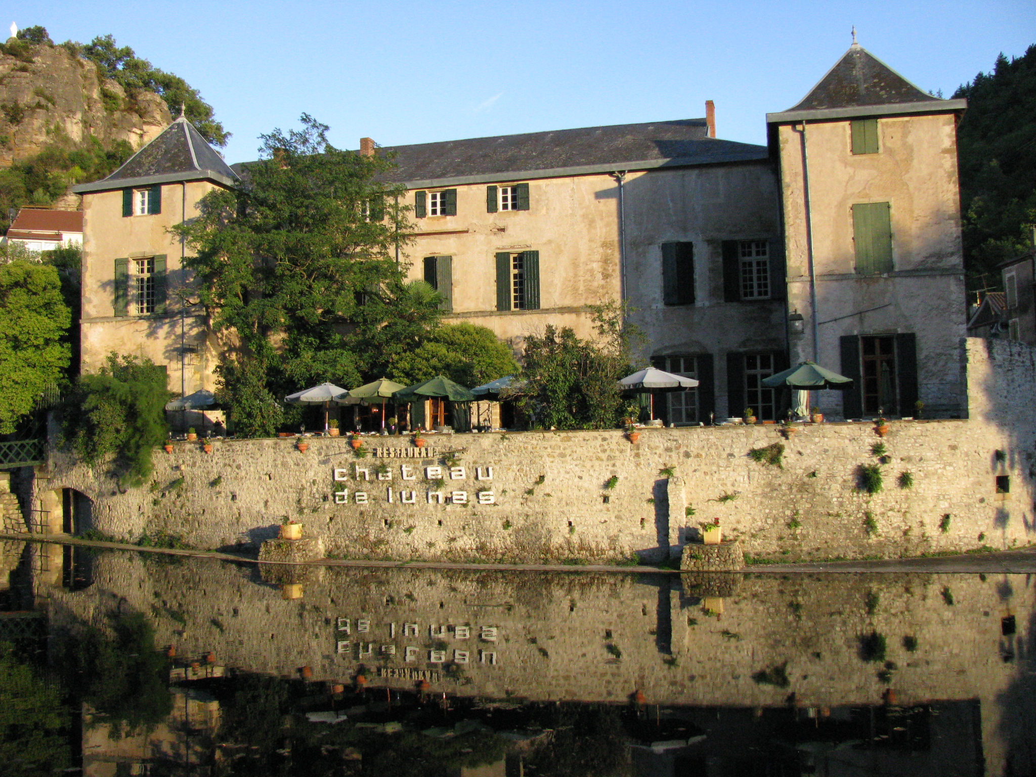
We went back to the street at about 7pm and made our way to Chateau de Lunas, a rather large and prominent three storied stuccoed building nestled calmly against the river Gravezon by a rock retaining wall. The place was old but well-appointed and now owned by a Dutchman with English and German ties. The dining room was elegant and contained about 20 tables. Our menus came as paper parchment secured to a raw slate tablet. We were going to pay for this! Paul was impressed! We had two beers each and then a liter of red wine. I had trout. We were back in our rooms by 9pm.
The Hotel Chateau de Lunas Mirrored in the River Graveson
A quick check of my feet showed things to be reasonable. My right foot appeared to be OK and the pain in the ankle had disappeared. The big blister on the heel had bled occasionally but no pain; simply need to continue to pay attention to it. The small blister on my left foot is OK but the ankle hurt today and I’ll need to be conscious of how the top of the boot gets tightened.
Monday, Sep 20: Day 6 – Lunas to Saint-Gervais-sur-Mare – 27 km Monday morning broke sunny and cool and perfect for walking. After a well-laid-out breakfast at the hotel we donned our packs and were away on a back street that angled up across the hill behind the hotel. The street quickly spawned off a gravel cart path which continued to angle up the hill. Both sides of the cart path abutted small enclaves of fruit trees planted in pockets of soil that had been stone-walled to retard erosion. Every few hundred feet an alcove would hold one or two benches (or occasionally a stone work shed) obviously established as a place to rest for those who tended the mini-orchards. From the layout of the mini-orchards, the ‘fussiness’ with which some were being attended, and the benches we interpreted those tenderers to be older residents of the community who could not, even in retirement, separate themselves from the land. The ‘orchard trail’ eventually re-intersected the highway and shortly after we found ourselves entering a small village – Saint Martin d’Orbe where we ran into Leddie again, finding out he is legally blind. He looked lost and claimed he could not find the trail. Some speculation suggested he was actually waiting for us. Further communication between Brian and Leddie at a picnic table revealed he was on some form of pension, and as a result he had apparently spent the night under the stars.
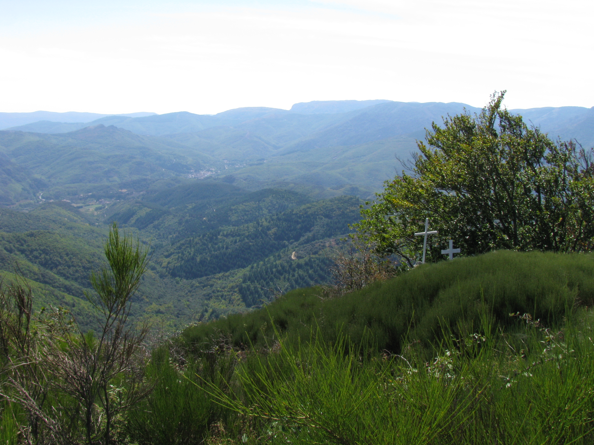
The Rugged Hill Country East of Saint-Gervais-sur-Mare
The trail out of Saint Martin d’Orbe saw us climbing back up into high country over a narrow, steep, gravel path. The lower reaches of the trail wound through stringy, dwarfed hardwoods and about half way to the top we began to encounter red florescent paint on trailside trees designed to provide extra visibility under foggy conditions. The crest of the ridge was covered in a mixture of hardwood and conifer, some wild and some plantation. Not far from where we attained the ridge summit we could see the location of what appeared to be a substantial observation tower adorned with several types of communication antenna. The consensus was that it had been designed as a fire tower from which to keep watch over the forested plateau. Perhaps 20 minutes beyond the sighting of the tower we came to our first evidence of current logging – a small brow of hardwood logs/limbs ranging a few feet to perhaps 16 feet long. The irregular crookedness of the logs suggested firewood, but with careful selection some pieces could have been turned into furniture furnish.
Over the next few hours the trail wound us through numerous conifer plantations, some of which showed evidence of the first thinning by the mechanical extraction of every fourth row. They appeared to be perhaps 50 years of age. Occasionally a small patch of conifers within a larger stand would show clear evidence of having died from some form of pestilence; at least one such patch showed evidence of recent salvage harvest. Between the plantations would be areas where broom had taken over the roadsides, and the side hills were covered with low-lying brush and broom. Boar rootings were common along the roads; Paul saw a squirrel. The forest had obviously been planned in part for recreation as it contained scattered picnic tables in choice locations and an occasional observation tower where spectacular views obtained.
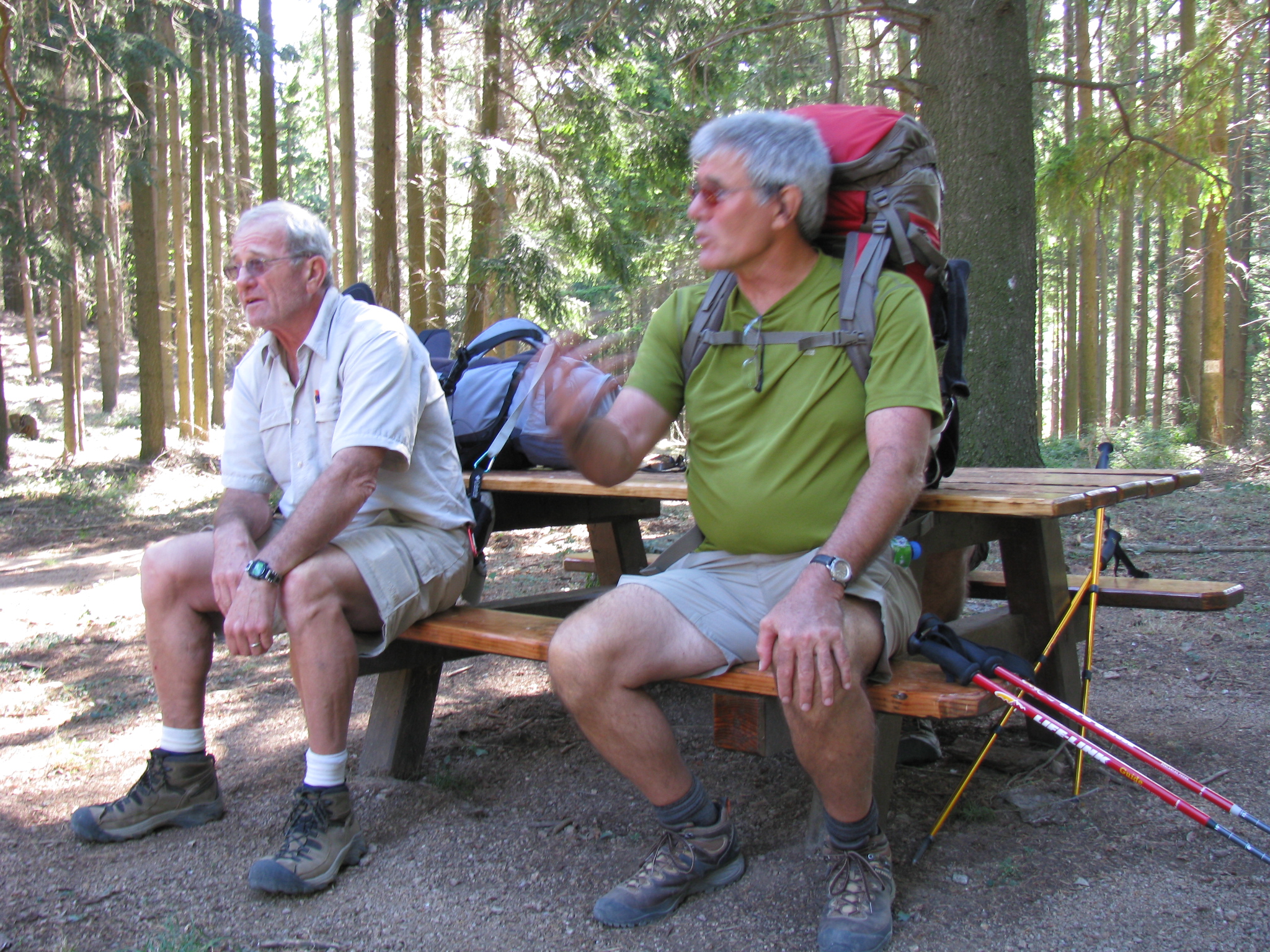
Mike and Brian Taking a Breather on a Picnic Table in a Community Forest Plantation
Of most interest it had been planted over soil-retaining rock terraces, suggesting that the landscape had probably been in vineyards at some time in the past. It was not uncommon the see “fresh” patch cuts on hillsides in the distance. In one area just off the road we noticed a small stone house in good condition and assumed it to be a base for workers in the forest. At about 11am we met Odette and Francis at a shelter at an impressive overlook and engaged in another positive conversation with them. The shelter was new and obviously constructed for observation purposes. It was of sufficient size that it could have provided on-trail shelter for three or four pilgrims; however because of an open front one would need to pray for fine weather. We decided to have lunch at the shelter. Leddie left with Odette and Francis. Immediately past the shelter the forest road passed through an impressive plantation of beech, perhaps 70 years of age.
At about 3.30pm we began the descent off the plateau to Saint-Gervais-sur-Mare via the small hamlet of Mecle, initially on a service road through a pine forest, then across some open hill tops, and eventually down a steep rocky trail through dwarfed hardwood into the hamlet. There were a couple older, and one younger, ladies sitting in the shade obviously enjoying the lazy afternoon as we came into the hamlet of stone and wood homes. We asked directions and they were provided, perhaps a bit shyly. We stopped at the hamlet fountain for about 15 minutes, catching our breath and refilling our water bottles. During that time a man, who turned out to be a Brit, appeared on a balcony in a building bordering the fountain area and provided detail on the rest of the downhill to Saint-Gervais. He had owned the unit for about 9 years and had moved there permanently some four years ago because it allowed him to stretch his British pension dollars further than he could back on the old sod, and as he admitted, it was a good place to live if one preferred ones own company much of the time. Of interest, the wooden door of what appeared to be a grade-level garage across from the fountain had nailed on it trophy feet from five wild boars and one deer. The rock wall next the fountain held a colored drawing of a pilgrim on the trail between Lunas and Saint-Gervais, situated conveniently at Mecle. The drawing appeared to have been constructed around a circular metal plaque containing the typical Camino scallop shell motif draped with words Camin Roumieu.
Our final downhill from Mecle was about 3km and we elected to take the road as opposed to the more dangerous, steep and slippery trail. Just before we entered the community of Saint-Gervais we crossed the river Mare on a relatively new highway bridge with stone-walled sides. Immediately upstream, perhaps 100 feet, was a second really attractive, arched bridge of stone and cement, said by the guidebook to have been constructed in medieval times but no longer in use.
The guidebook described the day’s section of trail as follows: “The walk from Saint-Martin d’Orb to Saint-Gervais sur Mare is a strenuous high level walk involving much climbing and effort. But the splendor of the scenery and the feeling of being on top of the world (or at least of Languedoc) makes the struggle worthwhile unless the weather is bad.”
We had (for some weird reason that escapes memory) tried to phone ahead to reserve rooms at one of the gites listed in the guidebook but got no answer. As we walked into town at about 5pm we noted a lady, an attractive and stylish redhead it turned out, parking her car ahead of us. Immediately after passing the car Brian asked of another lady where we might find accommodation. The redhead by this time was out of her car and overhearing our conversation said “Come along!” and we dutifully followed her through town to the municipal office. She marched us up the steps and into the office and told (the redhead turned out to be a town councilor!) one of the young female clerks in the office to look after us. Even though it was closing time the clerk, who had a reasonable proficiency in English, cheerfully obliged and marched us a few further blocks down the street to what turned out to be the new municipal gite, just opened that spring. Prior to leaving the municipal office the young clerk had also booked us accommodation for the following night in the next village. The gite in Saint-Gervais du Mare was perhaps the best appointed, or close to the best, hostel I had stayed in on my Camino wanderings.
After getting out of our packs Mike and Brian volunteered to go for groceries and beer while Paul and I showered away the sweat and dust of a rather long and hard day and washed clothes. I was just into writing up the days experiences when Mike and Brian arrived with the refreshments. There appeared to be one other pilgrim in the gite and it later turned out to be Leddie who had arrived before us. A young unfamiliar couple arrived later; if they were pilgrims we never saw them again.
We went out for dinner perhaps at about 8.30pm and finally settled on a restaurant with outdoor tables and an apparently strong clientele. We took an outside table as the evening was quite pleasant and ordered small salads and pizza (yes, again!). We initially ordered four small of each the salad and the pizza but optimistic Mr. Barker, obviously in collusion with the proprietor, convinced us to upgrade the salads to minis and the pizzas to large. Well, it turned out that the four mini salads would have fed an orphanage, but since they were so good, and arrived ahead of the pizzas, we wolfed them down and washed away any lingering taste with red wine. Then came the pizza!! OMG they were gigantic and of course we could not finish same. We took four half pizzas (well, less two pieces of Paul’s) back to the hotel and ended up carrying them for the next two days before finally forcing the last bites down at lunch on Wednesday. Admittedly, it was excellent pizza, and I’d recommend the Mexican with beans!
While at the restaurant we encountered three guys at the next table speaking English with an Australian accent. They were biking through southern France (not Camino) and enjoying it. They were just leaving the restaurant but we exchanged pleasantries for about 10 minutes.
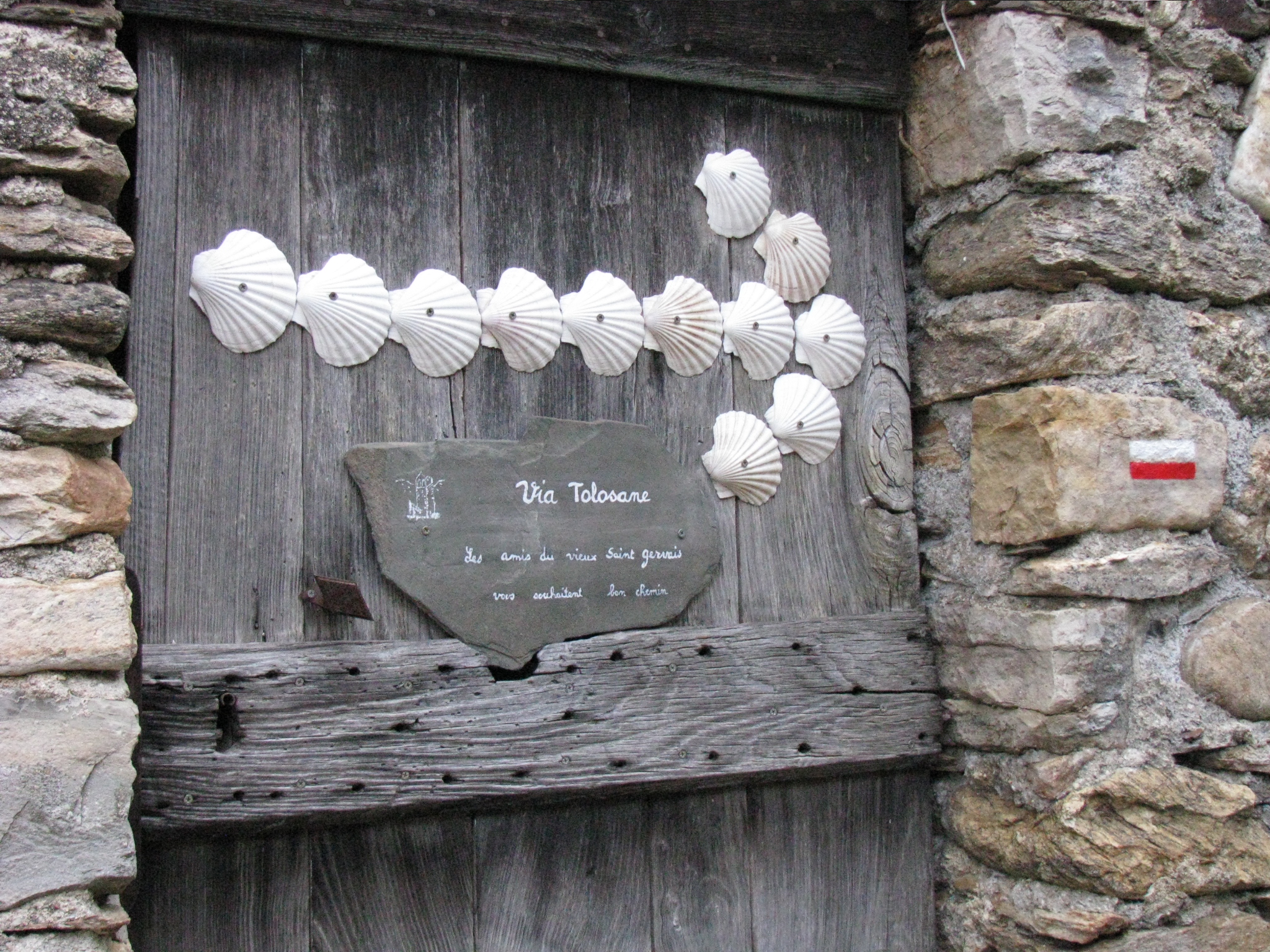
Tuesday, Sep 21: Day 7 – Saint-Gervais-sur-Mare to Murat-sur-Vebre – 26 km We left our favorite gite early and traversed most of the village following the main street upstream along the river Mare. At the end of the street the redirection of the trail was marked by a white arrow comprised of 12 scallop shells attached to the door of a small stone building. A small adjacent slate sign said Via Toulouse and additionally one of the stones of the door frame held the neat red and white striped marker designating the Camino 653 trail. From this point the trail headed uphill through scrubby hardwood and it took us about 45 minutes attain the ‘summit’. It was exceedingly steep and I found it to be the hardest going of the trip, requiring frequent “breathers” over the last 25 minutes. It appeared to me that the climb was affecting me more than any of my companions, including Paul with his less than fully-functional feet. I began to wonder if my relative condition was simply a matter of my being ‘out of shape’, or whether I should chalk it up as old age settling in. In retrospect, I am of the opinion that my unusual breathless condition on that climb was in fact a harbinger of a light heart attack I was to suffer some 14 months in the future.
Marking the Trail out of Saint-Gervais-sur-Mare
Vegetation going up the side of the mountain was generally poorly-formed hardwood at the beginning and conifer further up. Toward the top of the climb it consisted of a mixture of patches of better developed and mature chestnut and conifer forest. Forest roads abounded on the highland. After about 4 kilometers we arrived at Andabre which we essentially traversed on a poor quality road adjacent to the low-flowing Mare river opposite the core of the village. Beyond Andabre the trail tended to parallel the river Mare, although a bit uphill, for about 2km. In that distance the trail passed through mixtures of pine and beech and other deciduous species. One feature adjacent to the forestry road was a dislodged rotting stump of a large tree. The diameter of the tree had been in excess of three feet, the root ball immediately under the surface had been perhaps six feet. The fact that all the roots had been sawn off the stump suggests it may have been dug out as part of the road construction initiative. Also along the road in one wet spot were numerous tracks of wild boar. We also passed a narrow, elongated patch cut of perhaps three acres from which all trees had been clearcut. The size and thickness of the poplar regeneration would suggest the harvesting had been done the previous winter. Surprising, a copious amount of small stove-length blocks up to perhaps 5 inches in diameter adjacent to the road had not yet been retrieved.
The trail eventually led up out of the Mare river valley on a number of forest roads traversing stands of conifer, beech and other hardwoods. At essentially the height of land we passed a large unoccupied stone hunter’s lodge known as Maison de Sayret adjoining a couple fields which that particular day contained a number of cattle, some of whom were ‘bawling’ in fine voice. It was at this point we again encountered Leddie and eventually directed him forward on the proper trail after a false start or two.
Perhaps 10 minutes past the hunting lodge we encountered a lone pilgrim, Alaine, who was travelling east. He was perhaps 40, bronzed, fit, outgoing, spoke three languages, and had been on the trail for three months. He had given the keys to his apartment back to the landlord when he had set off the Santiago, which he achieved via the north route along the Atlantic. That initial experience had obviously been positive as he had walked back on the Camino Frances and now had his sights on Jerusalem, via Rome, and eventually Nepal. He estimated he could do it in two years. Also during the day we ran across the bearded Frenchman Gerard again. During this encounter it came to light that he is a practicing psychologist from a town near the Belgium boarder and he will only be the trail for two weeks because of family responsibilities; his wife does not like the idea of him walking alone but calls him every day to ensure he’s safe. In addition we saw two new male walkers today and Brian ran into a couple others we’d seen previously.
To that point in time we had met two individual French walkers who had offered that they were not prepared to walk into Spain because of anticipated language difficulties. Generally the French people we had met on our journey had been most pleasant and helpful. This contrasts with the prevalent French attitude on the Camino Frances which had run something like “If you are from Canada how come you can’t speak French?” Gerard confided that the French generally like Canadians; someone else suggested that there is a need to show that you are working at the language.
About an hour after we met Alaine the trail took us through a recreation area designed for kids from perhaps 6 to 14 years and called Cap sur l’Adventure, its ‘clubhouse’ being situated in a refurbished stone farmhouse. The paraphernalia on site consisted of nets and tree stands and swinging ropes hanging from wire lines. A cursory look at the setup suggested it was simply an accident waiting to happen and one would never be able to cover the liability insurance in North America.
The afternoon also produced two additional logging experiences. The first consisted of a small clear-cut in conifer, the 16 foot sawlogs from which were piled by the roadside awaiting pickup. The second was the operation of a mechanical harvester thinning a conifer plantation; the enterprise appeared to be a first cut which took out every fourth row and the occasional small stem from adjacent rows. Just beyond the thinning we came across our first and really healthy fir plantation that had just recently reached “free-to-grow” stage. Not far after the thinning operation the trail led us through a small beech plantation containing at least two ages of trees, the presence of multi-stemmed younger ones suggesting an earlier harvest.
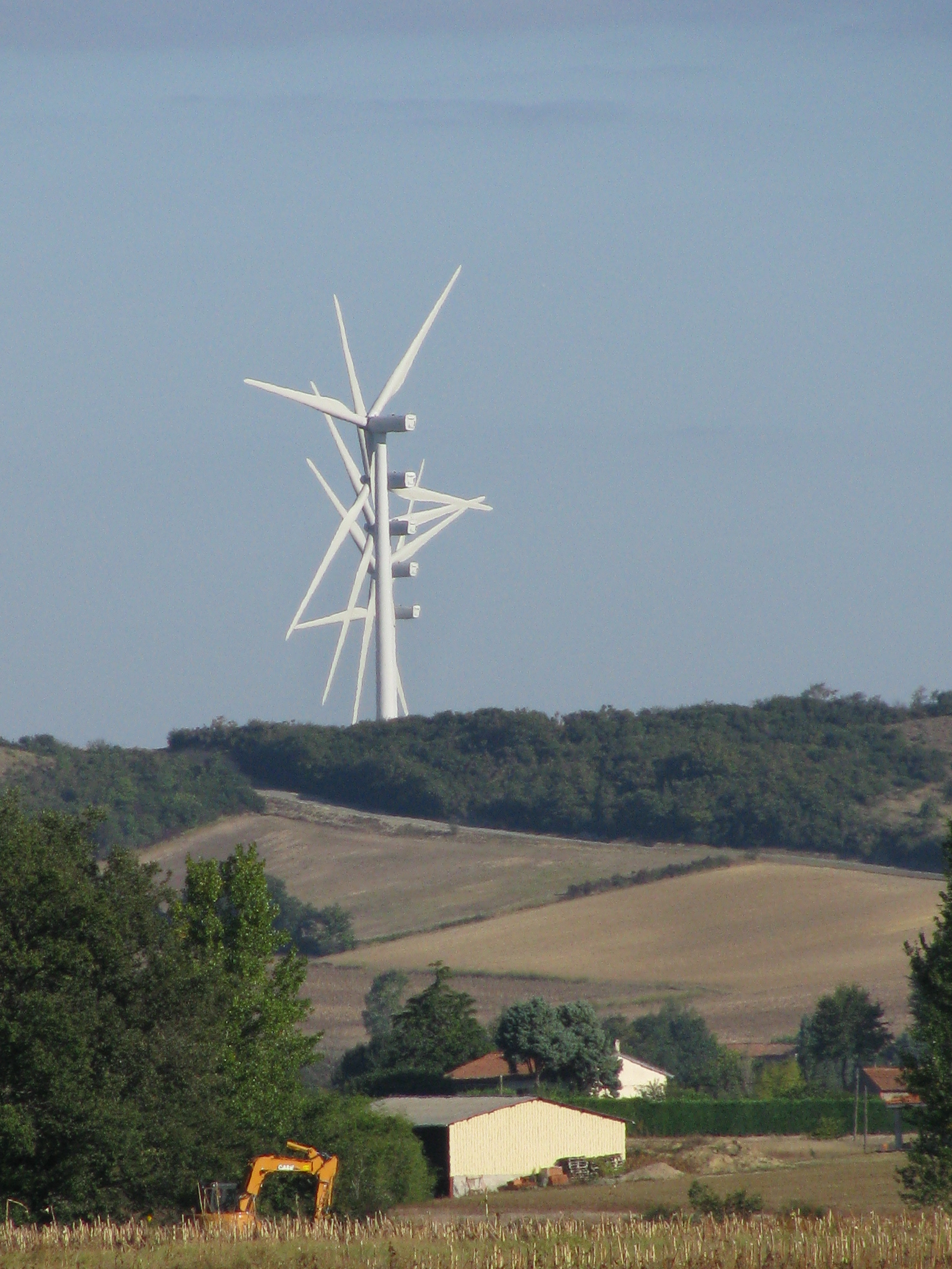
A feature of the later afternoon was the coursing of the trail along and through an active windmill farm that appeared to have only recently been established. Our walk took us up close and personal and past perhaps 12 working windmills; the noise from which was deemed not bad. Passing the windmills the trail began to descend through conifer plantations and lower down the beach plantation mentioned above. When the trail broke clear of the forest cover we were exposed to a vista of rolling hills covered by a patchwork mixture of farm fields (40%) and interspersed woodlots (60%). The farms tended toward cattle, both white and brown, although two flocks of sheep were also noted. Intuitively we realized that for the most part the highlands were behind us.
The Post-Highlands Rolling Mixed Farmland and Woodlots East of Murat-sur-Vebre
In a few kilometers the trail led us into the small village of Les Senausses where many of the buildings boasted the first slate roofs we had seen in France. Additionally, several older buildings in the community were paneled on the west and/or north sides with slabs of slate of about 3 feet in the vertical dimension and from 15 inches to 36 inches in the horizontal. This was a feature unfamiliar to our experiences to date in Spain and France. Along the trail we did notice one ancient farm house perched up on a hill with the recent addition of a new red steel roof; we assumed it was either a lodge of some kind or else the private estate of one of the local nouveaux riches. Gerard had informed Brian that the good folk of Les Senausses were widely known for their habit of eating chestnuts. We noted similar slate roofs, some most attractive, in our target village of Murat-sur-Vebre.
Between Les Senausses and Murat-sur-Vebre the trail ran along farmers’ fields and through woodlots. Windrows along the fields were common and in one location the windrow was composed primarily of a well-maintained holly hedge perhaps 10 feet high and skirting the road for perhaps a half kilometer. In a couple instances we noted both fence posts and hydro poles to have been poured cement. We arrived in Murat at about 4pm and gained access to the municipal gite via registration at the town office, which office appeared to be situated in a school. The gite, which was up the road a bit, had only eight beds and we commandeered the four singles. The place, while not particularly luxurious, was serviceable; the toilet was sans seat. Leddie arrived shortly thereafter and the five of us were the only residents in the gite that evening. Brian had overheard Gerard earlier in the day telling the two French guys that Leddie had been late today because he was out of cash; the guys apparently helped him with some via an ATM. Gerard at the same time also indicated that Leddie had been having nightmares in his sleep; that must have been his circumstances our first night out at Saint-Guilhem-le-Desert. We suspected Leddie was crashing at the gite without registering but we’re OK with that and would cover him if necessary. The good Doctor Gerard appeared to have been intentionally shunning Leddie as he must have noted that Leddie had a need for medical assistance; he had earlier told Brian he would not take on any work on the trail.
Supper tonight was at a good restaurant and all four of us had salad and frogs legs washed down by some ‘saucy’ local red. On the way back to the gite I snubbed my toe on the curb and fell flat on my face, scraping my knee in the process; otherwise only my pride was bruised!
Wednesday, Sep 22: Day 8 – Murat-sur-Vebre to La-Salvetat-sur-Agout– 21 km In the morning we, including Leddie, ate early and were off in relatively cool morning air heading west. A ground fog was hanging over the community cemetery when we passed giving it an eerie luminosity; however, during the day the sky was clear and what I described as ‘excruciatingly blue’. The temperature was probably 240 C, simply excellent for walking. We passed a couple small dogs in a small fenced yard, obviously starving for affection. Their presence led Brian to relate a story of befriending a street dog in a little village in Turkey and as a result coming down with (and home with) some kind of foreign disease that almost did him in before a specialist in foreign diseases on the Canadian side of the pond got a handle on it and eventually developed a successful management strategy. As a result Brian now exhibits great caution around stray dogs.
Walking today was through landscape that mirrored late yesterday – farmers’ fields offset among woodlots. Cattle viewed in the fields were both of the white persuasion (Charlois?) and the red persuasion (Limonsin?); we saw two flocks of sheep. Some of the woodlots were part of larger managed community forests. In one instances a relatively large single oak and a chestnut tree had identifying plaques attached. In one location the trail ran along the southeast shore of a small lake, Lac du Labuzas, which appeared to be a section of the river Vebre dammed for water power purposes. The late fall drawdown had left the water perhaps 100 feet out from its high water mark. The hilltop village of Villelongue markd the termination of the lake and we ate lunch there in front of the church with its good view of the lake. We gave Leddie a Mars bar and he immediately wanted to share it with us.
Leaving the church and community the trail again progressed through restored woodland and in one place we passed a restored, one-room stone house with an elaborate slate roof, an attached iron cross of Saint-Jacques with an affixed scallop shell, and signed “La Jasse dal Balccut”. The structure was sans door and its interior tended to be musty, although dry. Iron crosses tended to be common along this part of the trail. We later saw spruce trees in a plantation that were probably close to 3 feet at the butt, and at least two brows of such material piled roadside awaiting transport; counted annual rings on the butts gave an age of 33 years. Given good soil conditions conifers do really well in southern France and we had probably been overestimating tree ages!
The Trekkers Back-dropped by a Brow of 33 year old Conifer Sawlogs
We entered La-Salvatat-sur-Agout from the east. Its walled village center was constructed on the hilltop in medieval times for fortification reasons. The Romanesque chapel of Saint-Etienne-de-Cavall (the inside of which has been recently restored) dominates the upper village center; the narrow streets, shops, houses, and viewscapes make it a “must see”. Once in the community we set about seeking accommodation and approached Hotel Auberge de la Resse situated across the river and about a kilometer out of town; Leddie diverted on his own to find a gite. The Auberge de la Resse was an older inn with shower/basins and toilets down the hall; however, it was well maintained. Our room had both a single and a double bed. Upon arrival I had the usual shower, washed clothes, and took a Motrin (Mike has nicknamed Ibuprofen “candy”). A quick review of my feet indicated they were not bad – my left ankle was considerably less sensitive and the earlier blister on the toe had weathered today’s trip with no additional complications; - my right foot was OK except for the blister on my right heel. I had let it go the previous day without a cover but this am decided I’d better cover it with a compeed. By 10 am it was stinging a bit so I changed the compeed to an “H” shaped bandage, resolving most of the stinging. However, by the time we arrived at 4 pm I noted both thighs to be a bit sore; perhaps they needed a day off.
The owner/hostess we estimated to be German/Swiss and in her early 40s; most pleasant! It being Wednesday she was hosting an “after the hunt” lunch for perhaps 50 hunters from an organized club who had been boar shooting that morning (remember, the season is open on Wednesdays). They were in fine form and advised they had bagged two deer and one boar. (By the way, Brian had seen a deer run out of a plantation and into a broom-engorged cutover late in the morning). Our hostess made us plates of cold cuts and salad for a late lunch and we washed it down with blond Belgium beer out on the patio. We later ate a comfortable dinner in the restaurant, with only about three tables occupied.
Thursday, Sep 23: Day 9 – La-Salvetat-sur-Agout to Le Rialet – 31 km We appeared in the dining room for breakfast at 7.20pm which consisted of croissants (Paul passed judgment that earlier ones were better), bread, butter, jam, apple juice, and coffee. There was one additional lad in the dining room at the same time. He had long hair and spoke French but was not walking; I classified him as Quebec Aboriginal, perhaps in sales or movies. He drove his own car.
The hostess indicated she had had to go out and buy apple juice prior to breakfast as she had not started making her own yet this fall. She turned out to be a Belgian from the north part of the country. Mike pegged her accent as close to that of his Dutch in-laws. We met her husband, a forest worker, who showed us pictures of harvesters mired in mud. He indicated that, in spite of our positive impressions, the forests of the area were in bad shape generally. They were being affected by two kinds of pests, one of which looks like a budworm.
Our trek today continued on old trails over more forest and fields, cattle and a couple flocks of sheep in the fields, harvesting in the woodlands. None of the walk was in highlands and all in all it was quite pleasant. Just on the eastern outskirts of Angles we passed a small local sawmill with a number of 2-3 ft diameter conifer logs in the yard; one product was obviously 4x6 timbers. We arrived in Angles at about noon and had lunch on the lawn of the closed tourist building (they were always closed!); the community was not impressive. We met Alaine and Marcel who were staying in Angles with Leddie; they had previously passed us on the trail and arrived at about 11.30am. There were apparently only six gite beds in town. Their intention was to make the 32km to Castres tomorrow. Primarily because of the early hour we decided to carry on and with a target of the village of Le Rialet. On traversing west out of Angles we passed a bit of a recreation area which contained a tipi of white canvass about 12 feet diameter at the base, which appeared to be available for rent.
At Rialet we engaged lodging at a chamber d’hotel in a farmhouse about a kilometer out of the village. We were met at the door by the proprietor’s 85 year old mother because the proprietor had had to travel to Toulouse where his wife had a medical appointment and the trains were on strike. The gentleman proprietor had little to no English and was perhaps 48-50 years of age.
The farmhouse in which we elected to stay was something of a unique structure. It was old but had been retrofitted with a stucco exterior and the windows were decorated with bright blue wooden shutters. One section of the upper story had been outfitted with slate cladding we had seen elsewhere in the area, although the roof tiles appeared to be of the typical half circle red brick variety. The section of the farm house to which we were assigned was highlighted by one large room with an elaborately tiled floor and a two story peaked ceiling set off with hand-hewn support rafters. Artificial light in that room was provided by a rather plain hanging eight-light chandelier. This room appeared to have been le chamber grande from a former era. Adjoining the chamber grande on the second story was a loft with perhaps three bedrooms; the bathroom area was below the loft. The building we were told dated from 1762! The proprietors lived in the adjacent section of the house which was much more modernized. We took both supper and breakfast in their quarters.
The proprietor appeared to be running a few head of cattle and a couple horses. It turned out he was in reality a civil servant and a hobby farmer on the side. Obviously they took in pilgrims to assist in the cost of maintaining the historical structure. After dinner of trout, potatoes, green beans, venison pate, bread, and apple strudel we finished up by engaging the couple in conversation, compliments of Brian. It turns out he was a ‘forest bureaucrat’ working for some level of government, the level of which did not become quite clear. He had keen interest in issues pertaining to the forest and we garnered the following:
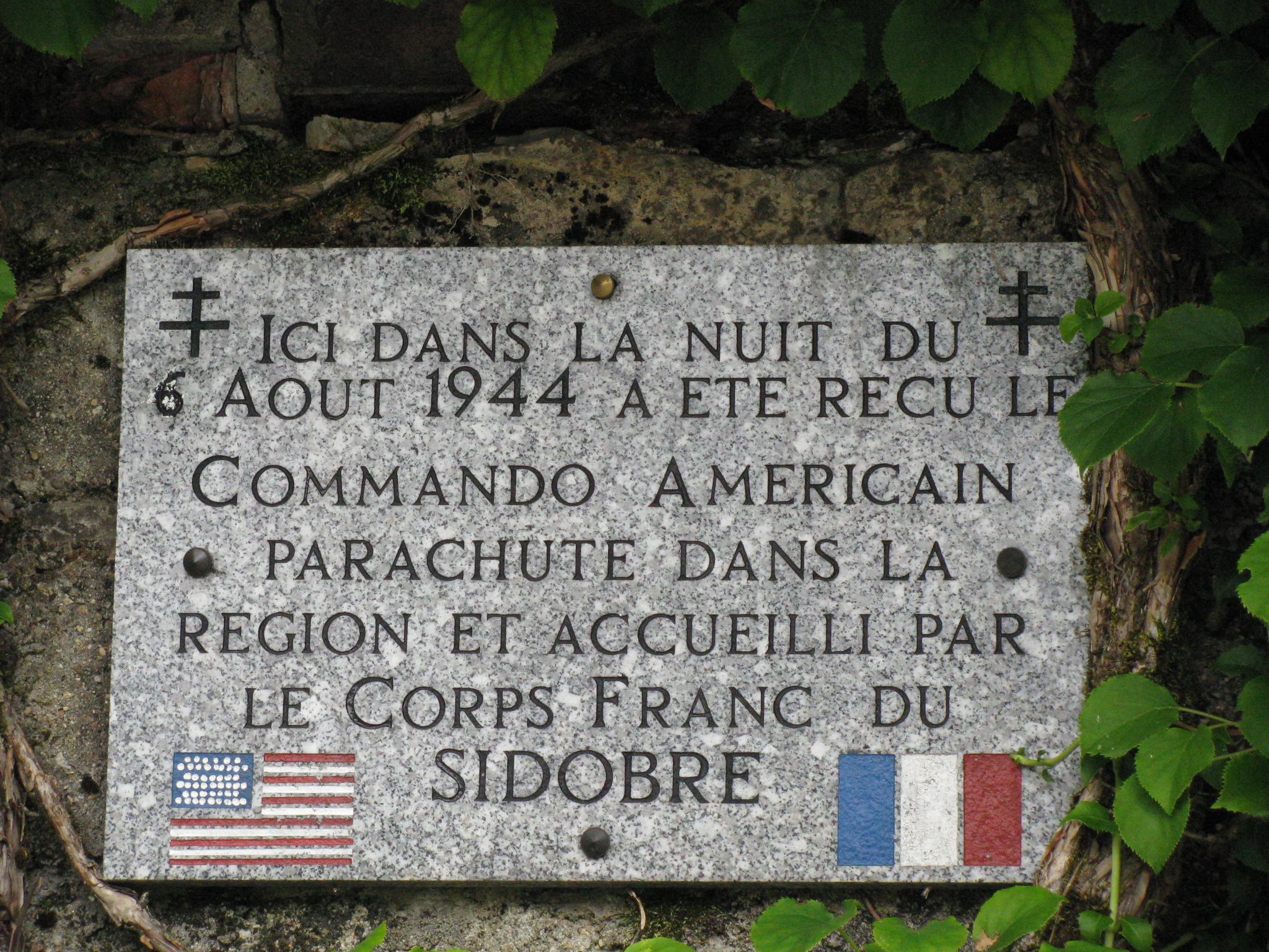
Just prior to arriving at La Rialet we noted several plaques along the trail/road, all recognizing an American nighttime parachute drop in the area on August 6, 1944. It had been designed to bring information and support to the local resistance Corps d’France du Sidobre (about 250 souls) which had been given the job of halting the Nazi retreat back toward Germany. The Americans (15 individuals) successfully connected up with the Corps which subsequently on August 12 engaged the Nazis and captured most of the retreating soldiers, some 4200 men, 80 officers, and all their equipment. On the night of the drop two of the Americans stood off a Nazi patrol in the woods about a kilometer from La Rialet while the rest of the squad made off through the forest. Both Americans were wounded and eventually died of their wounds; they are buried in the Le Rialet cemetery. There is strong recognition of the US effort in the area to the point that the local forest near the village of Bouisset was renamed The Forest of the Americans, and the farm house at which we stayed had a prominently displayed mounted granite plaque commemorating the initiative.
A Plaque Honoring American Commandos at the Farmstead near Le Rialet
Friday, Sep 24: Day 10 – Le Rialet to Castres – 24 km During the night the wind came up and it became obvious from the noise on the roof that we were involved in a rain event, a situation predicted by the cloud cover that moved in mid-afternoon the previous day on a freshening east wind. Mike subsequently attributed this waking rainstorm as a signal from dear friend Marion Wright of her passing. We left (after extracting Paul from the clutches of the little kitten that who was trying to kidnap him) in the rain at about 8.15am in full rain gear, assisted by our host who kindly drove us perhaps two kilometers to the point at which the trail left the highway. Our first couple hours were walked in a mixture of rain and heavy fog; it was impossible not to sweat in the rain gear in the high humidity. We had lunch in a bus shelter along the river in the town of Boissezon; what we saw of the community was not very impressive but that may have had more to do with the fact we did not get into the town proper.
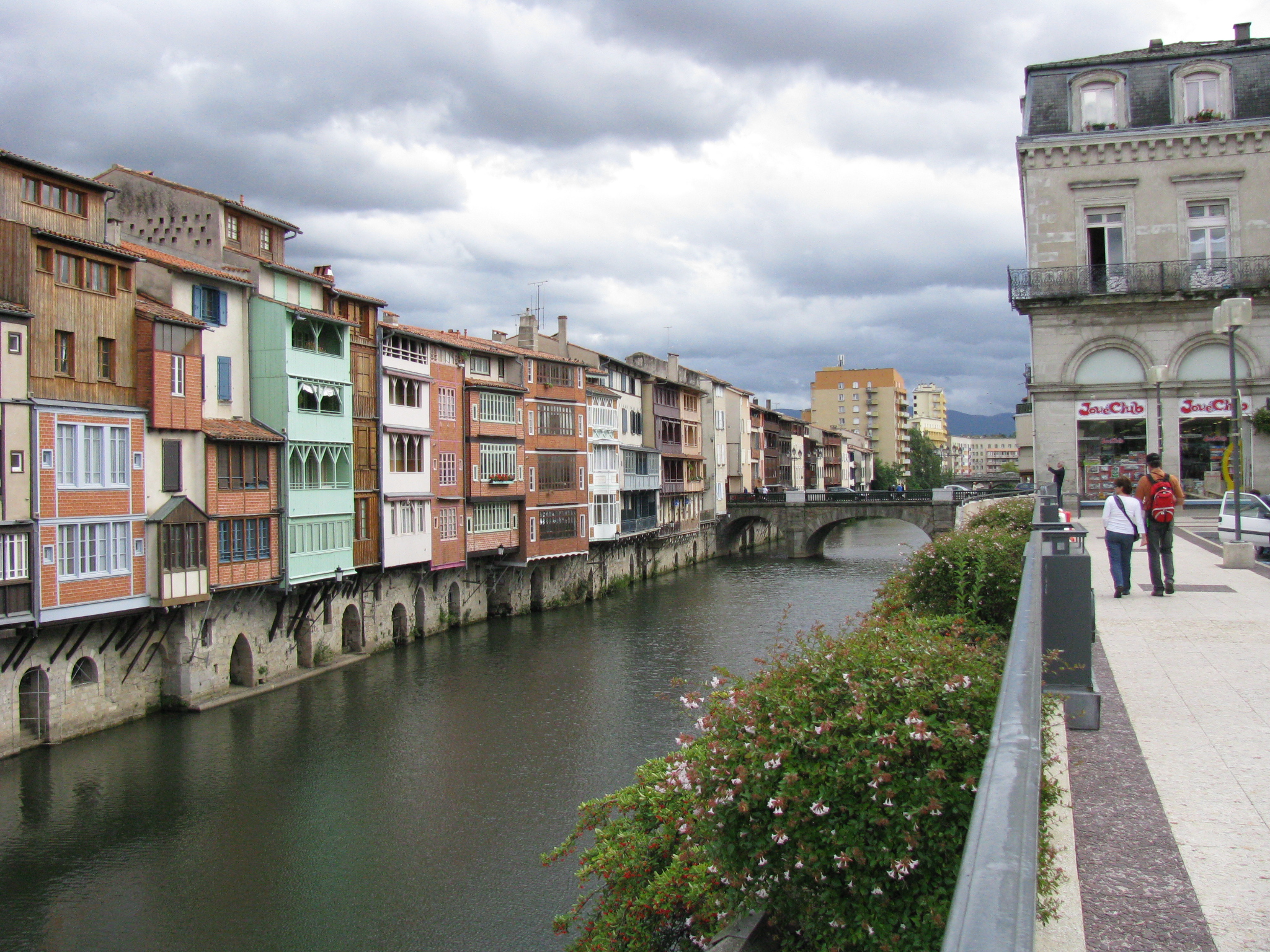
The rest of the day’s walk was not particularly memorable, although the weather improved by early afternoon with higher overcast. We arrived at the outskirts of Castras at about 3pm; it took us about a half hour to walk into the city. It came across even in poor weather as an interesting river-focused community, with much boating activity on the water of the river Agout. Multi-storied, multi-colored Medieval houses, originally constructed for workers in the community’s thriving textile industry, tower over some sections of the river and give the city a unique and charming appearance. We elected to take on a perhaps three star hotel near the city center but had to wait until 4.30pm for it to open from its mid-day closure. No room at that inn and they directed us to a second probably two star facility just down the street where we secured accommodation – 17E including breakfast.
Row-housing along the Waterway in Castras
A quick inventory of our feet showed Ray’s to be in the best shape since the beginning of the trip, providing the sense was that the boots were finally broken in and that the secret of tying the tops had been mastered. Paul still had a couple blisters which were giving him problems, one of which has progressed from the ball of his foot up between his toes. His left knee, which he had wrapped in an elastic bandage for the past few days, continued to give him some pain. It was at about this time that Paul assumed the title of "The Knight of the White Garter" as bestowed by his walking companions and which he carried (proudly?) for the rest of the adventure. Brian’s only difficulty was a black toe he self-generated by kicking a rock. Mike had overcome the shallow blister of the first couple days and was riding high! We looked for a computer café but were told that the only one in town had recently closed permanently. The young lady at the hotel desk let us use the hotel computer and we got a chance to get out a message or two.
We had dinner in the same establishment where we’d had the beer in the afternoon while waiting for the hotel to open. While having that beer we had seen Leddie with his distinctive gait passing by across the square; we never saw him again. Rather than outside under canvass we elected to eat dinner inside the restaurant. Kangaroo was on the menu and we could not pass it up! To top off the day we had a brandy in Mike’s room and hit the sack at about 10.15pm.
Saturday, Sep 25: Day 11 – Castres to Dourgne – 21 km We were down for breakfast at 7.30am. It rained hard while we were having breakfast but thereafter we only experienced a couple light showers and we had our jackets off by noon. We had difficulty finding the trail out of the city so we made our way back to where we had seen the last marker and progressed on downstream along the river. That little exploratory walk led me to an office of Camino-associated Catholic priests(?) in front of which stood a wonderful statue of a pilgrim in full stride, obviously walking into the wind. Except for the depicted garb, how characteristic of the real thing!
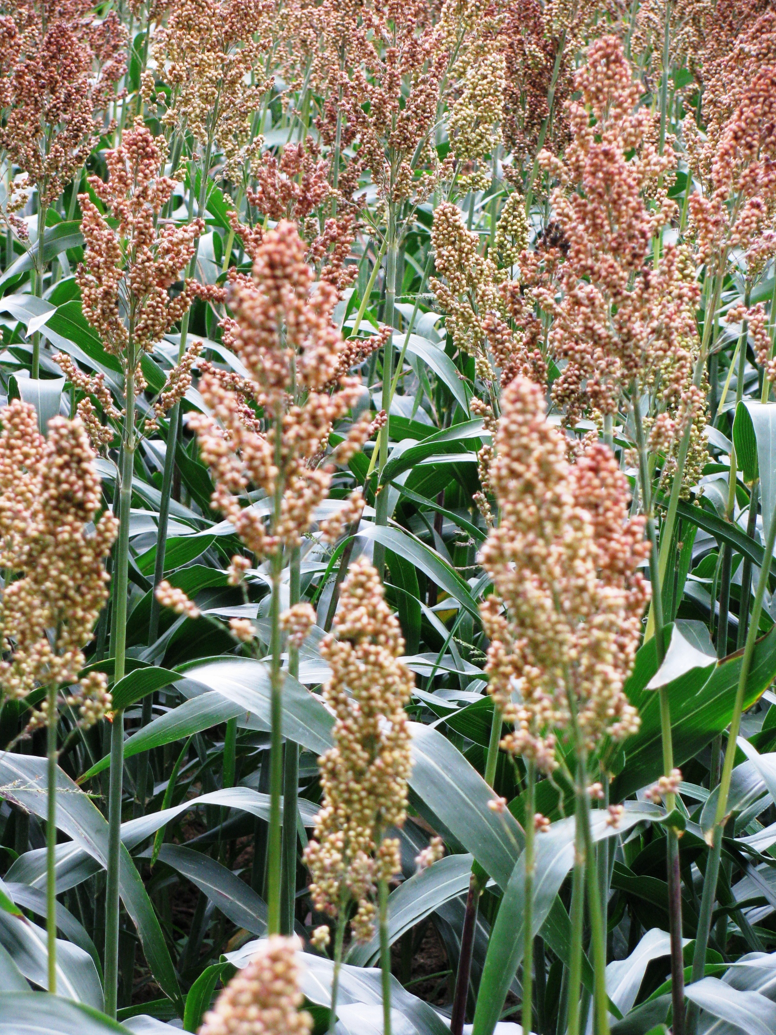
Most of the day's trek took us through farmland. We had seen our first field of corn yesterday and today we came into sunflowers and the cattle feed I used to call “mangle greens” back in NS; it is also known as mangled beet. We came across our first field of a plant none of us had ever seen before – it in some respects resembled corn but had a darkening elongated seed head at the top. I photographed it for posterity’s sake. After much consideration and searching of memory for potential crops more prone to southern climes, I made the bold suggestion it might be sorghum, although I’d never seen the plant before. Lucky guess…it was!
Our First Exposure to Sorghum
We missed the trail a couple times during the day – once to a distance of 1.5km and once to the tune of about 2.5km. In one instance we were sent back downhill by an older local walker whose new mission in life was getting the pilgrims off the pavement; it worked! The walk today was about 24km, including getting lost. The trail was partly paved, partly gravel, and partly muddy but it was not difficult. We appeared to have walked out of forest country into what was becoming predominantly fertile farmland. We did see a dead porcupine (?, but sure looked like one!) on the road today, some cattle egrets with cows, a fruited quince tree, and a small roadside plant that manufactured slate products with what looked like several pool table tops in stock. And finally, we saw our first eucalyptus-lined road today with trees perhaps 2 feet + across the butt; their crowns had already been harvested at perhaps 18 feet up, and the second series of branches were already at 4 to 10 inches in diameter.
In a phone call on Brian’s phone Mike discovered from Fran that our friend Marion had passed away back in Sault Ste. Marie on the previous day. We also discovered that Pat Lang, Brian’s boss, had on the same day announced her retirement from Confederation College scheduled for mid-2011.
This day we found out was Brian’s birthday! He celebrated it by talking to the animals which included a couple donkeys, some cows, some sheep, and a couple horses. Given the fact that it looked like we’d finish early (we already picked up an extra day in the last three) we made a decision that we’d invest in a rental car and spend next weekend on the road in southern France and perhaps even elsewhere. It was deemed most advantageous in respect of price and insurance if the rental car was booked from Canada, consequently he had had his wife Dallis checking opportunities on the Internet. To celebrate Brian’s birthday we presented him with a bottle of brandy and some beer (which he then appropriately shared). The fact that it was his birthday had nothing to do with he/I and Mike/Paul having to share the queen-sized beds in the last two rooms in town!
We arrived in the village of Dourgne at about 3.30pm after having to backtrack into the community perhaps 1.5km rather than push on to the next village. There was beer but no computer café in town. The little village had a rather neat main drag with a treed boulevard up its center separating a number of interesting shops/restaurants on both sides of the street. We had seen a road sign earlier in the day that indicated 63km to Toulouse, so we had an option of a relatively short day. However, because it would be Sunday we were now conscious of needing not to get caught in a small village. We had dinner in the full dining room of our hotel on the main drag – duck and all the trimmings – and brandy in Mike and Paul’s room before bed. We came to the conclusion that perhaps tomorrow should be that easy day and we’d only walk as far as the next town, Revel. Sunday, Sep 26: Day 12 – Dourgne to Revel – 16 km We walked out of the village at 8.45am, after breakfast in our room, with hardly a body stirring. About a kilometer out we passed a field of dairy cows and noted one of the cows giving birth behind the hedgerow next our road. Most of the day’s walk was on roads with some quite busy as the morning progressed, likely with church being the prime target. We noted a dead bat along the road and several flying hawks. Two harvesters were working the cornfields. We started to see running water along the roads with intake pipes for irrigation of local fields. We noted that in one place the trail had been rerouted since the publication of the guide in 2002 and speculated that the change was intended to get the pilgrims into town.
We arrived in Revel at about 12 noon. Again we were wandering the street looking lost and the chief administrator of the town, another middle-aged female, took pity on us, asked us if we were pilgrims looking for accommodation, and proceeded to get the key to the municipal gite and lead us to the location. The gite was a bit of a non-descript building with 6 beds, and a small kitchen, upstairs; the toilet was downstairs if memory serves correctly. The facility had a volunteering couple posing as resident managers who were out at the time of our arrival. When they finally arrived back at the gite the guy appeared to be somewhat put out that the chief administrator had overstepped her authority and let us in, leaving him out in the cold in trying to fill the reservations he had already accepted. It took a few hours before he warmed up to us. At one point the administrator had requested of Brian as to whether our lack of Camino passports was a sign that we were not really pilgrims! The volunteer manager indicated that in his opinion we did not look like pilgrims and he would not have let us in until after six without credentials, and then only if there were available beds. He became much less negative after he discovered Mike’s Camino history. The volunteer couple had apparently walked to Santiago from Toulouse once (45 days) and biked once (15 days).
We went out for some repast and finally found an open bar that served as a horse racing parlor on the side. We slaked our thirst and then moved out looking for food. We found a sandwich shop/bakery where a young couple was making and serving sandwiches on demand. We ordered four large pita-style varieties along with fries; mine came with curry! After we each bought a small can of beer the chef offered us a bottle of his homemade red wine and then offered some chocolate stuffed pastry. Need I suggest that Paul accepted his kind offer which as much gratitude as could be mustered on a full stomach on a late September Sunday in southern France.
We had dinner in a pizzeria – mine Swiss steak in red wine gravy with a goat cheese salad. The meat proved to be a bit tough.
Monday, Sep 27: Day 13 – Revel to Labastide – 33.7 km We had breakfast with the volunteers consisting of coffee, bread, jam and some chocolate cake – Paul cleaned up the cake! By the time I realized the intention was to drink the coffee from bowls I had rummaged around and found cups and so we imports all drank from cups. We assisted in the clean-up and were on the road out of town by 7.45am. Near the edge of town we came to a water viaduct along which we walked for most of the day until we migrated to the road about 3km out of Labastide. Distance-wise this had been our best day, most of it on soft ground, and it appeared we had walked at about 5km/hour. The trail was for the most part downhill following the viaduct. The structure secured its water off the Black Mountains – Montagne Noire – to the south and east and had apparently been engineered along the edge of the valley specifically to ensure the water would be gravity-driven. Water was being taken off occasionally for irrigation purposes but the layout of the viaduct system suggested its origins were as a source of water for the more southerly Canal Midi which carries commercial and recreational traffic across southern France between the Atlantic to the Mediterranean. Short cement posts, some recently painted white, were common along the canal and appeared to mark property boundaries.
We saw three squirrels, one a big red guy without the ‘fox ears’; Paul saw a pheasant. Trout were not uncommon in the watercourse and we passed one fisherman at a bit of an enlargement of the viaduct. The enlargement sited a restaurant/coffee shop and picnic tables which suggested a formal recreation area. The water, which carried some ducks, local geese, and a black swan, was unfortunately full of algae and dirty.
We walked a total of 8.5 hours on the best quality trail we’d yet seen and under idyllic walking conditions. We passed two individual ladies who both reported having seen a couple of French Canadian guys walking, fast, toward Montferrand with the objective of ensuring the catching their flight home tomorrow.
Windmills are Common in Southern France – These SW of LaBastiede
The countryside was obviously big farming country – big equipment, and big fields of grain, sunflowers, sorghum, and corn.
We took the first hotel we came to, somewhat east of the trail and less used; it was older, refurbished, and had much character. The doorways were small and the floors uneven; however, the floors had just been refinished in vinyl flooring, new windows had been installed, and the bathrooms, though small, and just been redone. It was clean. The bar, which appeared to be the center attraction of the facility, was almost totally decked out in sports memorabilia, primarily soccer, and was festooned with football pennants. It was obvious that the owner, one Christian Pinet, had been a major regional soccer official in the past. He had a framed diploma in Football Management appropriately hung. While we were having a beer a couple of the locals arrived, had their beer and a smoke, talked with each other and the owner, and left. Somewhat of a good English atmosphere obtained. The owner had a number of bills above the mirror behind the bar including a blue Canadian $5. He advised there was no computer cafe in town.
Paul was initially concerned that the facility was below even our low quality standard; we suspected the irregular floors were a leading factor generating his concern. However, we collectively redirected his perspective of the ‘cluttered’ bar to one of a ‘character’ bar and he decided it was worth a go. When the barkeep put out snackies – peanuts/stuffed pickled olives(hot!)/small tomatoes along with dried duck pieces (and along with the later chocolate croissants) – it became Paul’s new favorite hotel. The barkeep’s sister appears to do the cooking. For dinner we had a melon-walnut salad and cassolet (this time a white bean/sausage/pork casserole) – well recommended!
Tuesday, Sep 28: Day 14 – Labastide to Villefranche-de-Lauragais – 19 km We left Labastide after being served a good breakfast by a lady we deemed to be the owner’s niece; she had her 11 year old daughter with her at 7 am. There was one older guy in the bar at that hour, a cyclist, apparently local, who carried his ‘stuff’ in a back pack and not in panniers. He appeared to have been having knee problems as one of them was covered with a stain that looked like it may have been iodine. On leaving Labastide we went back to the viaduct and traced it down to the major waterway – the famous 240km Canal du Midi (from Toulouse southeast to Etang de Thau) which, along with its westerly sister the 193km Canal du Garonne, forms the Canal des Deux Mers which trends through southern France connecting the Atlantic with the Mediterranean. The Canal du Midi was designated as a UNESCO World Heritage Site in 1996.
Big Farming Country Near Canal du Midi
The viaduct we had been more or less following since Revel took us directly into the canal system at the canal’s topographical summit via a major pumping station at a place called Seuil de Naurouze on the height of land. An Atlantic-Mediterranean canal system had been conceptualized during the 16th century reign of King Francis I but the concept suffered from insufficient water for its summit sections. In the 1660s a rich local farmer, Pierre-Paul Riquet, believed he could solve the water problem by capturing the water flowing off the Montagne Noire to the north and east and channeling that water for use in the canal’s summit sections. Approval to initiate work on the canal was given in 1666 and the canal was officially opened in 1681. The viaduct system from the Montagne Noire reservoir was a contoured channel over 25 km long, eventually equipped with 14 locks in order to bring building materials for the canal down from the mountains. The 240km Canal du Midi itself has 91 locks which serve to ascend and descend a total of 190 metres; it has 328 structures, including bridges, dams and a tunnel.
The Canal du Midi was formally commissioned just months after Riquet died. Its construction eventually cost over 15 million livres, of which nearly two million came from Riquet himself, leaving him with huge debts. His sons inherited the canal, but the family's investments were not recovered and debts not fully paid until over 100 years later. The canal was well managed and run as a paternalistic enterprise until the revolution.
We walked west along the canal for a short distance and then redirected ourselves northward and toward Montferrand which is a village on two levels. The upper village is an ancient hilltop fortification, the most prominent feature of which is the locked church of Notre Dame; most of the community activity today takes place in the lower village. The hilltops sits above the plain of the Canal du Midi and the views from there to the Pyrenees and to the Montagne Noire are excellent. The location houses an 1800 colored panorama which identifies and positions most of the main features out across the countryside. Additionally, the site holds an information board noting Montferrand’s participation in early air postal service between Paris and Buenos Aires, Argentina.
Most of the rest of the day’s walk was through what appeared to be a fall-brown version of the lush agricultural countryside of southern France. We came across, in no particular order, a brick bridge over a little stream showing much evidence of the passing of many feet over the decades, a single pilgrim of our age who indicated he had taken on the challenge of walking around France in three week periods (he was on his fourth period) over a number of years, a collective of six windmills set in farmland on a range of low hills, an active grain elevator system (the only one of the trip), some 20 snails all sitting on a single stem of a dead plant, a donkey which Brian tried to pat, a 25 year old poplar plantation adjacent to the Canal, a plaque honoring the good American friend of France, Thomas Jefferson, on a building near the canal, and many heavy black-fruiting Viburnum sp shrubs in the windrows and along the roads. Cattle and sheep were not apparent in any numbers so most of the crops must be ‘exported’ from the local area.
After a light day of some 19km we took hotel rooms in Villefranche, a bit upscale from the previous night but lacking the previous evening’s “character”. The dining room had been recommended by our pilgrim friend from the afternoon. Dinner that night was veal. Our pilgrim friend’s recommendation was spot-on!
Wednesday, Sep 29: Day 15 – Villefranche-de-Lauragais to Donneville – 25 km We left Villefranche at close to 8am and spent most of our day, except for the first 1.5km getting out of the town, along the Canal du Midi. The walking was pleasant today as most of the Canal was tree-lined and the dappled shade was a welcome friend. Prominent signage along the Canal promoted cycling. We noted some pretty artistic graffiti on the pillars of an overpass, suggesting that we must be approaching an urban area. By 9.30am I photographed Brian perspiring via a cloud of moisture captured by the sunlight of the cool morning. We passed one set of workers finishing off the pillars of a new overpass by setting round cobbles in a wet cement base; we saw another group with a bucket truck pruning some eucalyptus.
Watercraft of all shapes and sizes abound in the Canal, their prime requisite is that they be of appropriate height and width to allow them to pass through/under some of the smaller bridges spanning the Canal; one bridge we saw suggested that at least in this summit area, 14 x 14 feet might be the maximum practical size. Many of the boats were moored to formal docks, some to stakes driven in the ground, and a few less permanent tie-ups to trees. Docking appeared to be predominately focused on the south side of the Canal. Many of the boats were modern and of a recreational nature; some were longer and used for commercial purposes (e.g., restaurants), and finally some appeared to be used for accommodation, either seasonal or permanent, but the apparently lack of people aboard suggested weekend/seasonal use. Potted plants, including tomatoes, were a common attribute of these latter varieties. Many of the larger craft appeared to date back to the 1930-1950 period and had an air of ‘home-made’ about them. Many of those appeared to be renovated barges. The one small marina/shipyard we came across appeared full.
The Canal shoreline housed the odd restaurant, one in a former stone house had no room at lunch time, so we took out lunch in a recent restaurant of the fast-food variety sited on a cross road perhaps 250 meters off the Canal. Away from the Canal farmland was
A Typical Early Morning Scene on the Canal du Midi
the order of the day; the frequent presence of unharvested sunflowers in a dried out state suggested some possible constriction on their harvest/sale and we wondered if quota may have been an issue. Off along the roads away from the Canal what looked to be the bright orange fruit of North American winterberry holly was abundant in the windrows and ditches; we wondered if it represented a European escapee. By midday the character of the canal’s adjacent landscape had changed to a mixture of rural and urban landscape with the increasing presence of newly constructed apartment buildings and hotels. In one area what may have been an upscale modern six story condo building had been constructed adjacent to an expansion in the Canal that we interpreted to be a turning basin for boats that were too large to traverse the summit section of the Canal. A plethora of expensive boats were tied up to dockage adjacent to the condo building.
Canal water was full of algae and an off-green in color. Ducks, mostly mallards, abounded. During the day we saw a swimming animal, probably a nutria, a crane of some type, a pheasant, a rabbit, and a bunch of magpies.
We met one retired Brit who had worked in Canada (Wpg/Van/To) for six years; he noted he had not liked Toronto. He also went on a bit about not liking French wine because it was all being made “old-style” when all the rest of the world was going “new-style”. We also saw one of the three Aussi bike guys we had talked to at dinner in Saint-Gervais-sur-Mare nine days previous; he was awaiting the arrival of his two buddies who had taken the train.
As the day grew longer the traffic on the trail increased – a lot of bikes, many runners (both male and female), and many day walkers, mostly of the older generation. These individuals for some reason appeared to become less friendly as we drew closer to the city.
At about 3.30pm we ran across a modern hotel just off the Canal – a member of the F1 chain – and made the decision to bunk there rather than to walk into the center of Toulouse and try to find accommodation after 6pm. The hotel was perhaps 10 years old. Rooms were about 10x12 feet and had both bunks and a sink built into the wall; toilets and showers were down the hall with three of each to service about 50 rooms/floor. The rooms had flat-screen TVs. The door locks were of the combination type and the guest needed to remember not to misplace that combination. On returning to the room after dark we found it full of flies attracted to the light; we made short order of them by washing them down the sink!
There was a local restaurant a short distance from the hotel called Buffalo BBQ with an American Indian motif (!). It opened at 6.30pm and did not serve alcohol. The meal was quite OK; the internal décor interesting.
A review of our physical shape showed Mike with his first serious blister (on walking day 14 no less!). Brian’s heels had become sensitive and he had a bit of pain in one knee, both likely due to our two 30km days. Paul continued to have difficulty with at least one of his earlier blisters, he continued to wear the elasticized knee support on his right knee, and unfortunately he appeared to have created some hip problem when twisting while throwing his pack on earlier in the morning. Ray was best described as OK!
Thursday, Sep 30: Day 16 – Donneville to Toulouse – 9 km We began the short walk into the city of Toulouse shortly after 8am along the Canal, our only problem dodging the early morning cyclists and runners; there were few walkers out at that early hour. We thought we would be able to walk in on the north side of the Canal but the walking circumstances became constricted by an adjacent busy city street so we changed to the south side of the Canal at about 8.45.
The architecture on the outskirts of Toulouse appeared to be modern for the most part. As one would suspect it became more ‘classical’ as one progressed to the center of the city, although some of the architecture in the vicinity of the train station, including our hotel, had a 1950’s feel to it. Buildings in the core of the city were generally three to four stories high, and the stories appeared to carry 9 to 12 foot ceilings. Shutters, generally ornamental, were common, and some of the newer, ostensibly apartment, buildings had balconies. There was a multi-level parking structure a couple blocks from our hotel that had probably been built in the 1980s and would have been a comfortable fit for Toronto. Overall the city we saw appeared modern, clean, and welcoming.
Early Morning Shadows of the Pilgrims Across the Canal du Midi Approaching Toulouse
We arrived at the Toulouse train station (reasonably large and refurbished) at about 9.30am and found the rental car section. After much haggling and some good advice (make your reservation by e-mail!), Brian had Dallis make us a reservation for a car for the morrow am. There was no need for a special licence. We moved across the street from the train station and began checking out hotels; the first one wanted 92E a night we deemed too expensive; the next three were booked; the fifth was OK (not great, just OK) but it was handy and the desk staff friendly so we booked in, reserving rooms for Sunday night as well. We later discovered that the adjoining street corners were occupied by ‘working girls’ from about midnight to perhaps 7 am.
“Downtown” was only perhaps 4 blocks away so off we went to find a big beer to toast our accomplished walk (346km point to point). We later ordered muscles (I had the curried variety!) and fries in the outside section of a downtown restaurant and subsequently we were back at the hotel at 3pm. Brian found a combination Internet café/coin laundry and we all made quick tracks in getting there. I abandoned my last pair of hiking shorts after 1200km!
After getting ourselves squared away for our motoring adventure of the morrow we walked down to the river Garonne which courses through the middle of Toulouse, had a beer, listened to a bunch of pick-up musicians playing jazz in the corner of a small square, and eventually had dinner in a pizzeria; the service was not particularly good. After the meal we spent a few moments with brandy in hand trying to set out some of the verbal highlights of the past 16 days:
· “I’m only a minor government functionary who could go missing at any time” from a street tourism assistant in Castres upon our asking for direction.
· “Whoa, slow down coach!” as proffered by Mike several times when he was having difficulty keeping up with the details of the conversation.
· “Stay calm, be brave, wait for the sign!” heard a couple times when we were having a hard time finding the trail markers.
· “Those French! They have a different word for everything!" as per American comedian Steve Martin.
· “She's been gone since Thursday evenin' and I got a hunch I'll never see that gal no more." a line from a bit of a story which tended to catch our silly fancy.
· "Mama these pails is heavy!" we used it but I can't for the life of me remember why!
· “Oh shiittt! We’re really screwed!” heard a couple times when we made a wrong turn.
· “I scoff at your (whatever)!” invoked to inform one of the compatriots that his (whatever) was of insignificant importance.
Lights out at about 10.30pm in anticipation of a full day at Carcassonne!
Friday, Oct 1: Day 17 – To Carcassonne and beyond by car
We had breakfast in the hotel at about 7.30am – well done! We left for the train station car rental location at about 8.45 where it took us about 45 minutes to secure the vehicle; it took an additional 45 minutes to get ourselves organized and away from the train station. Paul managed to program the built-in GPS for Carcassonne.
It took perhaps an hour on the freeway to get to the exit to our destination; it took perhaps 10 minutes to get from the expressway into the community. There was a bit of a car show on in the main square which we mulled through before walking up to the fortification. The fortification was fully restored beginning in 1853, and added to the UNESCO roster of World Heritage Sites in 1997. Given our late morning timing we decided to walk back into the lower town for lunch before we ‘took on’ the fortification. A good decision!
For the record a bit of history on Carcassonne:
Settlement in the general Carcassonne area can be traced back to about 3500 BC. There is evidence of Roman fortifications in the area in about 100 BC. The Visigoths were formally ceded the general area by the Romans in 462 and are credited with founding of the fortress in the 5th Century. From the time of the Visigoths until about 1660 the city came under irregular ongoing attacks by expansion-focused leaders of city states, by the Protestant Cathars, by crusading European armies, and even by hereditary family members. The city submitted to the leadership of the Kingdom of France in the late 13 century. After 1660 the role of the city became more economic in nature and the fortifications were abandoned.
From Wikipedia: The fortified city itself consists essentially of a concentric design with two outer walls with towers and barbicans to prevent attack by siege engines. The castle itself possesses its own drawbridge and ditch leading to a central keep. The walls consist of towers built over quite a long period. One section is Roman and is notably different from the medieval walls with the tell-tale red brick layers and the shallow pitch terracotta tile roofs. One of these towers housed the Catholic Inquisition in the 13th Century and is still known as "The Inquisition Tower". Today there is a museum "Musée de la Torture", which shows some of the original torture equipment employed by the Catholic Church.
From the perspective of reconstruction the French government decreed in 1849 that the fortification was to be demolished so bad was its state of disrepair. However, the resulting hue and cry convinced to government to relent and reconstruction work began in 1853. In form the fortification consists of a double ring of ramparts and 53 towers.
The Entrance to the Trencavels' Chateau Dating from the Early 12th Century Inside the Fortress Walls at Carcassonne
We returned to the upper fortification after lunch and spent the next three hours, recorders in hand, self-touring the facility. To cater to the tourists as well as to allow the site to contribute to the local economy, the upper village within the ramparts is filled with restaurants/bars and shops. Had we known we may have had lunch within the upper town.
We left Carcassonne at about 3.30pm and struck out for the Mediterranean coast, turning right or south when we got there 45 minutes later. We took a sight-seeing drive into a new (20 years+/-) housing development (Port Lucatte) situated right on the water and just by chance ran into a hotel. Upon enquiry there were many rooms at the inn (off season) and so we booked in; our windows looked out over some pretty pricy boats moored at the community slips. We had dinner at a restaurant in the development, which was decorated with palm trees al la Vegas style. The next am we took the hotel’s breakfast offering which was quite reasonable, although for some reason it was noted that yogurt was lacking.
Saturday, Oct 2: Day 18 – Down the Mediterranean coast and up to Andorra by car We left the hotel at about 9.30am and continued heading south, and in perhaps a half hour transitioned from flat coastal plain to switch-backing over ridges protruding into the sea. Mike indicated we were now in “Catalonia” which overlays the French-Spanish border and which is populated by a hardy race of sea goers, sheep herders, and terrace grape farmers. We stopped at one seaside village – Banyuls-sur-Mer, the home of internationally renowned sculptor Aristide Maillol – perched for the most part on the adjoining hillside fronting a bay with a narrow beach. The myriad of modern recreational sail and motor boats plus a goodly supply of restaurants in the community spoke to an active weekend/seasonal come-from-away tourist cadre. However, as we walked the waterfront that Saturday morning we passed a couple locals mending a torn fishing net just off the main street.
Paul and His Favorite French Statue – La June Fille Allongee by A. Maillol – in Banyuls-sur-Mer
We continued south on the hillsides along the shore to within a couple hundred meters of the border between France and Spain where we turned around and began the trip back to the coastal plain from which we were to turn west and strike off to the Principality of Andorra. We stopped for 45 minutes for kebob sandwiches and a beer at about 12.30pm and then began the climb up into the Pyrenees.
The climb was spectacular but the road was narrow and less than straight as most mountain roads are. About half way up we stopped at another UNESCO site, this time fort Mont Louis built in 1722 and designed to guard the passes into France. Vauban, the guy that designed it, did such a good job that it set the standard of the day for the building of forts and he sited another 11 just in France that are also part of the UNESCO system. (Fort Churchill in northern Manitoba is of the Vauban style). Like Carcassonne, the fort contained a similar, although smaller, commercial retail center within the walls. The location is still used by French commandos as a training site; however, that portion is off limits to visitors.
To get into Andorra we were required to drive through Spain for perhaps 25 kilometers. Some of the area above fort Mont Louis was plateau and was being farmed. We saw a couple French police with automatic weapons spot checking cars in France just before the Spanish border, and several police in Spain doing the same thing. We were waved through in both instances. We entered the Principality from Spain via an efficient customs checkpoint. We noted that the Spanish border guards were focused primarily on youthful visitors returning home and several bottles of confiscated booze could be seen on tables where they were carrying out selective vehicle searches. Settlement in the country is all relegated to narrow river valleys and their immediate side hills which wind among the impressive peaks of the Pyrenees. The Principality’s infrastructure is modern – the principal ski area toward the French border reminded me of Banff – and efficient because of the lack of suitable developable land base. The following description has been primarily extracted from Wikipedia:
Typical Andorran Countryside in the Pyrenees
It was around 5pm when we arrived in the capital and commenced looking for a hotel. The first one we checked was full but the desk clerk referred us to a sister hotel down the road about 20km and made us a reservation by phone. We walked the streets of the capital for perhaps 30 minutes – parking was challenging – to get a feel for the community. I could not interest my colleagues in crossing a retail threshold, even if just to look at retail prices – something about “that’s girlie business”.
We had dinner at a small diner down the street from our hotel, a pizza place with about 10 tables. The proprietor had French Navy background and via that route he had spent time in Vancouver and Victoria. After discharge he had gone back to BC looking to buy a hotel. He had put in a bid on a facility on Salt Spring Island but lost it to a competing offer. He still has dreams of returning to BC. He has owned the current restaurant in Andorra for about 3 years; we got the sense that this location is simply an interim step. Beer in a bar in Andorra was 1.50E; food likewise was inexpensive as no tax! We had ravioli with cheese and sauce for dinner, slightly baked; really good! He treated us to one of the local liquors and he made a gift to Brian of a couple hanging prints off the cafe walls about which Brian had expressed admiration. Nice guy - Canada and BC would do well by his presence!
Sunday/Monday, Oct 3/4: Day 19/20 – Out of Andorra to Toulouse by car and Toulouse to Thunder Bay by plane We drove out of the mountain Principality back toward France leaving at about 9.30am Sunday. We were slowed down a bit at the French border by the sheer numbers of cars leaving Andorra; we were simply nodded through, perhaps because they recognized our plate as a rental. However, it took us about an hour to pass the line-up of cars on the French side of the border waiting to get into Andorra. Leaving Andorra was as one would expect pretty well all downhill, with a few switchbacks involved; excellent rugged scenery but mostly pasture land as opposed to a forest landscape, the forests having been harvested probably centuries back.
After the trip out of Andorra the details of the next day and a half tended to fade in the background, mainly because we were all looking ahead to next week and the things to be done at home. Near the edge of the Pyrenees we stopped at touristy spot advertising artifacts of early man but they wanted a sizable entry fee and the advertising tended to suggest something less than classic so we moved on without checking in. We had lunch somewhere along the road and got back to the hotel at Toulouse at perhaps 3.30pm. We got ourselves organized for the following day’s early departure to the airport (before 0540hrs) and then went back downtown for dinner. We congregated once more at the American Restaurant and had the mussels one more time – still excellent. Returning to the hotel we made arrangements for wake-up calls and the availability of a taxi to the airport at the appropriate hours.
I believe both rooms were awake before the call came in in the morning. Most of the working girls were still on their respective street corners when we left the hotel. We were not the first but almost the first clients at the Toulouse airport. Everything went swimmingly and we arrived at Charles de Gaul airport in Paris at about 8.30am. We had breakfast, did a bit of last minute shopping (believe it or not I found a replacement for the jet/silver bracelet purchased in Santiago in 2004 and subsequently lost!), and boarded the flight back to Toronto a bit late because of late arrival of the incoming aircraft. The flight back across the Atlantic was uneventful. Brian and I caught the 7.30pm flight to Thunder Bay, arriving at about 9pm with Sonja and Dallis waiting at the airport.
Postscript: Some post-trek observations:
RAR 27.07.13
|